Wind River High Route (Skurka Version)
DISTANCE: 97-miles
TRIP DURATION: August 9th – August 13th (4-days 23-hours 15-minutes)
START: Bruce’s Bridge
END: Trail Lakes
TRACK: https://share.garmin.com/3388
DAILY BLOG
Pre Hike
I arrived at the Riverton airport at 11PM. It’s the smallest airport I’ve ever seen, so small they only offer one flight in-and-out of Denver. I ended up carpooling in the same cab as the pilots, very interesting to hear them gossip about their job. The ride down to Lander was $65 which was cheaper than I thought. I got dropped off at the city park which offers free camping and quickly set up my tent to get some sleep since my day began at 3AM in Prince George (Canada). Woke up at seven and after breakfast I had a bunch of items I needed to buy. Headed over to the Wind River Outdoor Company which is the largest outfitter in town, same one I used in 2017 on the CDT. I desperately needed new shoes and they had a decent selection of Altra’s. I was looking for the new Lone Peak+ which they didn’t have so I figured I’d give the other outfitter (Iris) a shot after. Before leaving I bought two Peak Refuels, coffee, fuel, and exchanged my DT socks. I also picked up the permit needed for the WRHR. It ended up being $60 which was way more than I expected, this permit is only needed for a five mile section of the route. Made a pit stop at the Bike Mill to tighten up my trekking poles before heading over to Iris. They didn’t have the new LP+ either so I settled for the regular LPs. Only downside was they only had one color (purple) which I wasn’t a fan of. Felt incredible to finally ditch my Topos which ripped wide open on the last section of the GDT.
After a pit stop for coffee I headed over to the Holiday Inn and waited until my room was ready. It cost $200 on this Friday but I’m staying here because it’s next to the Safeway where my shuttle will pick me up at 9:15AM tomorrow. I asked the front desk if they had any bear spray left over from other customers but they didn’t. I decided to take the chance and just go without it. The grizzly population in the Winds is sparse and I’m only gonna be there for seven days. Cross my fingers. I checked into my room at 2PM and immediately did laundry. It had been eleven days since I washed my clothes and that was in Jasper. Afterwards I finished my resupply and I was officially done with my chores. I’m stepping off with 24,000 calories for the seven day trek, almost 3,500 a day. During my last section of the GDT I was running low so I decided to take a little extra this time. The weight sucks but the water carries will be light and it shouldn’t feel as bad after two days. I made sure to get the most calorie dense foods I could find. I spent the rest of the day pigging out on cold drinks, ice cream, doughnuts, and pizza. Lander is one of my favorite trail towns and over the years I have found myself here for different reasons. First the CDT in 2017, followed by a NOLS course in 2018, then firefighting in 2022, and now the WRHR in 2025

Day 1: 20 miles
Note: My daily miles is a rough estimate based on Andrew Skurka’s guide. I didn’t record a track during this trip so I don’t know my actual distance traveled but I absolutely hiked more than the miles I list
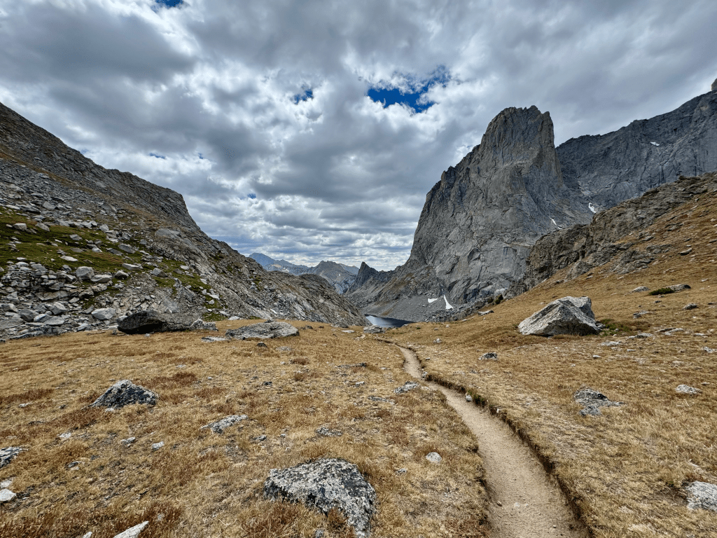
Got up at 7:30 and hit up the hotel breakfast. Took one last shower and packed my gear. Headed next door to the Safeway and got picked up by Wind River Shuttle at 9:30. There were four other hikers in there all doing the WRHR which is cool, wasn’t expecting that. Got dropped off at Bruce’s Bridge right before 10AM and immediately started hiking. The first 14.5 miles is all on nice trail. To me it felt like walking on clouds after what I experienced on the GDT. The whole way was a nice 2-5ft path. I ran into a couple people I saw in town the day prior, turns out they are also doing the WRHR and they are waiting on two people. So that brings the total to nine people starting the route today, secrets out on the WRHR I guess. I don’t mind company, it’s nice to talk to others especially since I hike solo. I reached the Deep Creek junction and I wasn’t sure it was accurate because it didn’t match up with my map and there was no sign for it. I took the path down and it still didn’t match my map. I bushwhacked back to the trail and after a few minutes noticed I was back on the Pinto trail going the wrong way, wtf. It was only a quarter mile back to the junction that turned out was accurate all along so I wasted about thirty minutes going in a circle. Stupid. At 4:20 I reached the point where you go off trail, now the fun begins. After a short climb I filled up a liter of water at one of the Deep Creek Lakes and had an early dinner at 4:45 when I found a big boulder for a wind break. Better early than on the exposed climb.
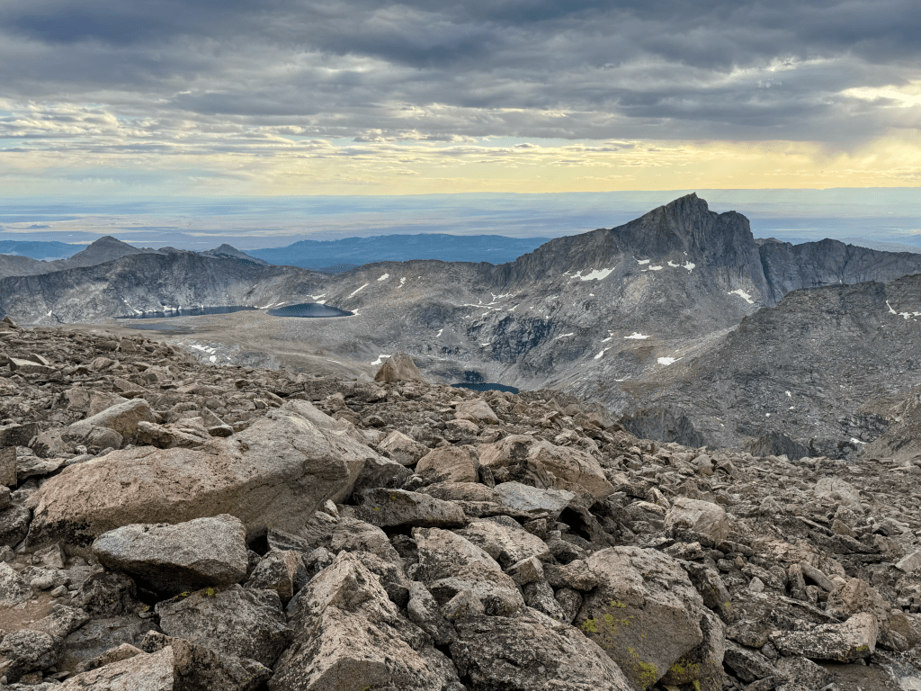
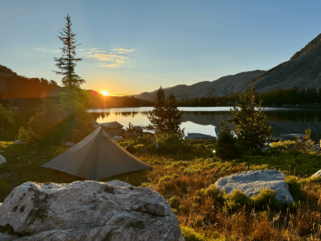
I started making my way to Chimney Rock first which is at 12,600ft and then Wind River Peak at 13,200ft. The climb wasn’t that steep but obviously slow moving as there is no trail. I could feel my heart and brain pounding pretty good which means I’m feeling the elevation. This was why I used the GDT as a warm up, the highest point there is only 8,500ft though. I made it to Chimney Rock at 6:15 and from the base of Wind River Peak it was 600ft in 0.4-miles. The entire final climb was boulder hopping and I summited at 6:45. Had it all to myself and it wasn’t even windy up there. Great 360° views as I expected. I couldn’t stay long because daylight was running out and I had one notorious section remaining, the West Gully. I heard this steep descent is the only time Skurka actually draws a line and tells you where to go on the map. It was indeed very steep but that isn’t the issue. The issue is the entire way is on extremely loose dirt and rocks, really loose. The first half wasn’t bad but the final half got a bit sketchy. A few times I would ride a wave of dirt down like a surfer. Listen to me when I say you cannot trust any rock in this section, even the big ones are often loose. The movie 127 Hours was on my mind the whole time. I did not want to end up in a similar situation pinned under a rock. Eventually I made it down and I shot a point back up top on Gaia and it said in 0.2 I lost 650ft of elevation, that’s steep. From there it was a lot of rock hopping until I reached an unnamed lake. I lucked out and found a flat grassy spot right at 8PM. I was worried I’d be hiking into the night trying to find camp. This spot could fit two tents and overlooks the water which gave me a great sunset to watch. The exact location is 42°42.81’N 109°8.35’W. This camp is at 11,200ft so it’s gonna be a chilly night. I do not plan on sleeping well due to elevation. I am also sleeping with my filter in case it gets below freezing. I’m glad I did both Wind River Peak and the West Gully descent on day one with a full pack. The peak is the only climb that’s over 2K (2,500ft) and the West Gully is considered by some (even Skurka) to be the sketchiest section of the WRHR. Nice to have them both behind me.

Day 2: 17 miles
Up at 6:30. Last night was much warmer than expected, my legs were sweating in the middle of the night. I only slept a few hours, couldn’t pass out until 3AM or so which is what I expected with such elevation. I made coffee and oatmeal for breakfast and started moving at 7:30. It was a long rock hop before going down to Black Joe Lake. I took accidentally took a much harder route down. I only did that because I was closer to it and it didn’t look bad from up top. I surely wasted much time descending this route because much of it required four points of contact. When I reached the bottom I looked back up and couldn’t believe I came down that. I walked the shore of the lake before I reached a section where its cliffed out. This required me to climb up and over to avoid it which wasn’t too bad. At the bottom I crossed Black Joe Creek over a makeshift bridge and I was finally back on trail!
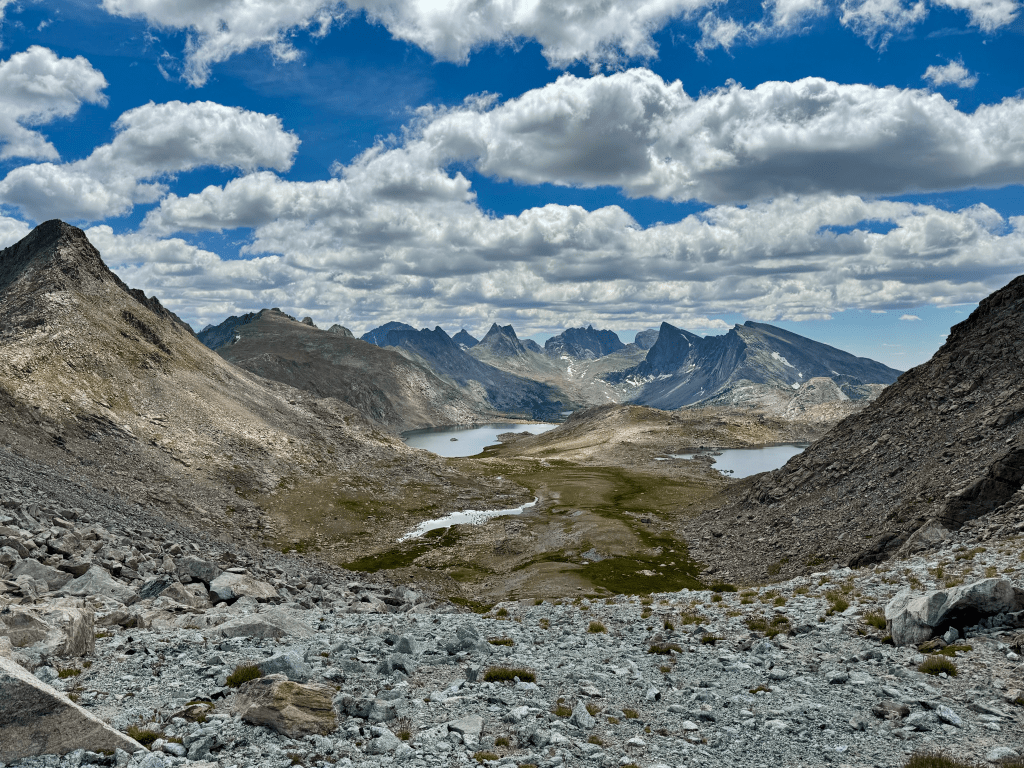
The trail going up Jackass Pass was frustrating. Every time I thought I was close I wasn’t. The trail kept twisting and turning and going up and down. Eventually I made it at 12:15 and had my first view of Cirque of the Towers since I hiked the CDT in 2017. Hard to believe it’s been almost eight years to the day since I’ve been there. Time flies. The Cirque is one of the most scenic parts of the entire 3,000-mile CDT. It’s an alternate that’s pretty much the unofficial main route because everyone does it. It sucks that both times I’ve been here I was in-and-out very quickly. One day I gotta camp there for a couple nights. The next pass was New York Pass to the west of Texas Pass which is where the CDT goes. The worst part about this pass was the boulder hop to get there. I should have stayed east of the stream and then crossed over. The final 0.1 had 400ft gain but it wasn’t bad. Footing was good for the most part and before I knew it I reached the top at 2:15. Epic views all around, especially looking down on Lonesome Lake and Jackpass Pass. On the other side was Billy, Barren, and Shadow Lakes with Bair Peak in the background. The climb down was pretty easy aside from some loose rocks. At the bottom I connected with Shadow Lakes Trail and then Pyramid Lake Trail. At 5PM I took my dinner break at the north end of Skull Lake before pushing on. I ran into four others who are doing Adventure Alan’s WRHR, that’s now thirteen people I’ve met doing this route. My plan was to camp right below Raid Peak Pass and from my dinner spot it required some cross country travel. Most of it was pretty enjoyable since it was flat with great views. I followed the East Fork with Mount Geikie to my left, Raid Peak and Mount Bonneville in front, and Tower Peak, Mount Hooker, Pyramid Peak to my right. I made it to a flat top at 7:30 about one mile east of Raid Peak Pass and managed to find a great flat spot for my tent. The ground was nice a firm when I put the stakes in, always a good feeling. Nothing worse than rocky ground when trying to pitch. I am two days in an over 1/3 done with the route. I’m far ahead of schedule which is good. I had seven days to complete the WRHR so all I needed was 14mpd. Currently I’m nine miles ahead so I have some wiggle room


Day 3: 19 miles
At 6AM it was surprisingly warm. Instead of breakfast in my vestibule I did it out in the open watching the morning light come over Raid Peak. Not a bad start to what’s going to be a tough day. The climb to Raid Pass only took forty minutes with more rock hopping, very happy I camped right below. Going down there were some “class 3 ledges and slabs” according to the map but I didn’t think it was bad. When I was going down I misread the topography and thought I had to go over a very steep ridge in the distance. When I reached the bottom I realized I was wrong and the route just goes below it and then over Sentry Peak Pass. What a relief.
Sentry Peak Pass was easy, just up and over a hump. Then it’s walking through Middle Fork Valley with mountains on all sides. The next pass is Photo Pass which is very obvious the entire way. Lee Lake and Middle Fork Lake dominate the valley floor as I made my way east of it. Photo Pass was easier than Sentry. It was a short climb but I was shocked to see a trail leading to the top. The view looking south towards Sentry Pass was definitely better than the northern view. The descent was loose gravel most of the way and once on the bottom I used an unnamed creek for a hand hail through a nice forested walk with many great tent-sites.
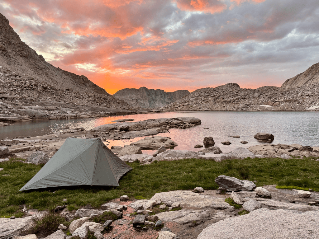
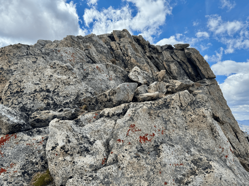
The day didn’t become interesting until 4PM when I made the approach to Europe Peak. The climb isn’t the biggest but it’s best known for its notorious knife’s edge. In Skurka’s map set he describes it as, “15-foot class 3 corner to knife’s edge, yeehaw!” I heard about it from hiker blogs and I was looking at it the night before in my tent, I knew it was gonna be the crux of day 3. As I made the long approach I could see the intimidating peak. I’ll be honest when I say it gave me a little anxiety, I couldn’t believe that’s where I’m supposed to go. However I just reminded myself that steep climbs always look worse from the bottom than when you’re on it. This peak turned out to be no different. When I reached the knife’s edge I realized there was plenty of footing and I could easily just walk across it, it just looked narrow from afar. I actually filmed it as I made my way through, it was that easy. At the top I still had a bit more to go to tag the summit. Great views and I was tempted to eat dinner up there but I wasn’t very hungry. It was only 5PM and I realized I could actually make it to Golden Lake, which is supposedly the best campsite on the WRHR. It was only 5-6 miles away and all flat, I cruised through it and made it by 7:30. To my surprise I didn’t see or hear anyone else, I had this great scenic place all to myself. Golden Lake is well protected from the wind because it sits a few hundred feet below the surrounding area. It’s like someone dug a hole and put this camping area in there. The temperature felt much warmer as soon as I descended. I found a nice tentsite overlooking the lake and called it a day. I dipped my feet in the water to wash away all the salt and sweat while I had the chance. Today was a big day, three passes, one peak, and still ended at Golden Lake. Couldn’t have gone any better. Looking forward to breakfast and coffee in the morning.

Day 4: 16 miles
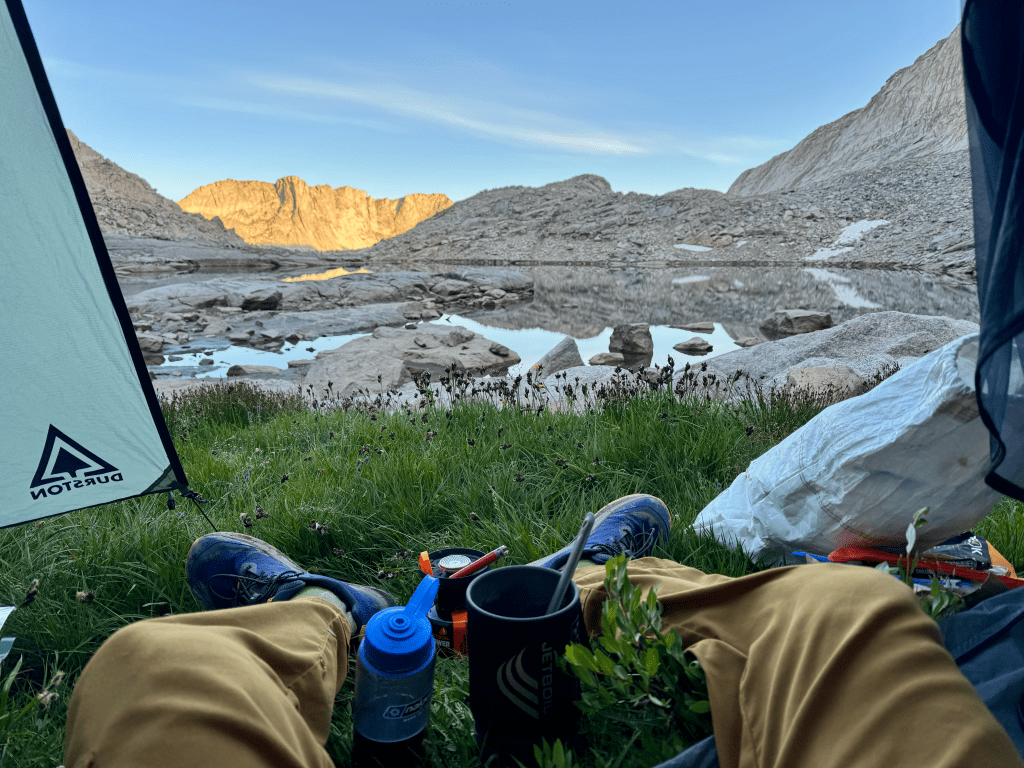
6:38AM – August 12th
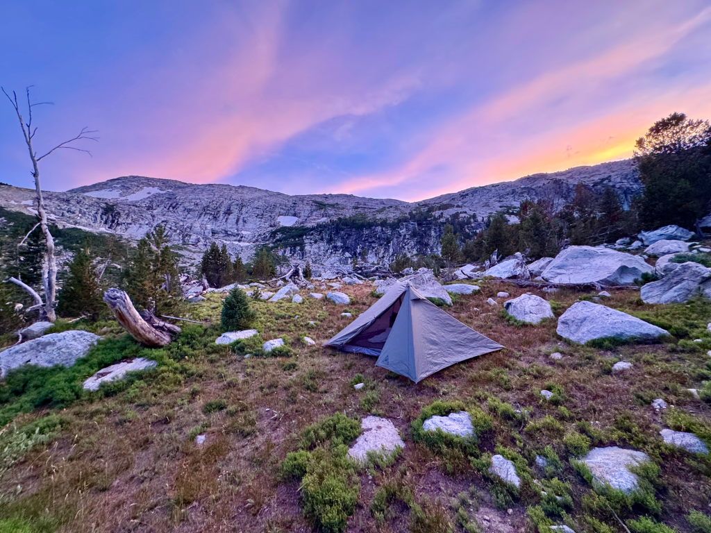
If you’re camped at Golden Lake around mid-August that is the exact time the sun will crest over the horizon and illuminate Golden Lake and the surrounding mountains. The way Golden Lakes is constructed is that there’s mountains and ridges to the north, south, west, but not the east where the sun rises. After 12,000 miles it’s one of the most epic sunrise I’ve witnessed on trail. The trip isn’t over yet but I already know this is one of the highlights. So if you’re lucky enough to be camped here make sure you wake up at 6:00 – 6:15 depending on how long it takes you to get out of your tent. You don’t wanna miss it. I found a nice flat rock in front of the lake to enjoy breakfast. Doubled up on coffee and had an extra packet of oatmeal.
Due to the epicness of the location it took me almost ninety minutes to break camp. I walked by Lake Louise and Upper Golden Lake and the sun had yet to hit either of those lakes. I don’t recommend camping there if you want a nice sunrise, stick to Golden. First thing on the to-do list was Douglas Peak Pass. Just like Europe Peak it looked incredibly intimidating but just like Europe Peak it ended up being quite simple. A word of advice. As you make the roundabout to the climb you are faced with a cliffed out section by the lake. You can either do a big climb to overcome it or get your feet wet for thirty seconds and shimmy along the lake. I went with the latter. It was knee deep (5-9) and no current, it will depend on the snowmelt so it might not be an option for some. When I came around the bend I ran into three hikers who did the former and they wasted a lot of time and energy doing so. The climb up from there was just like the others, steep and a bit rocky. I ran into four CDT hikers going southbound which I wasn’t expecting.
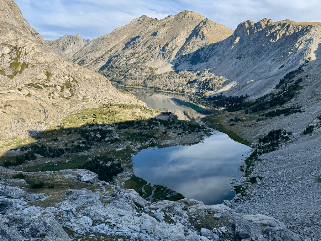
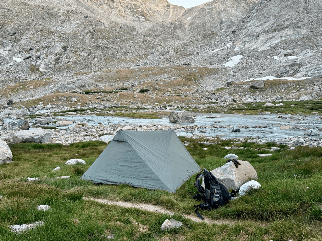
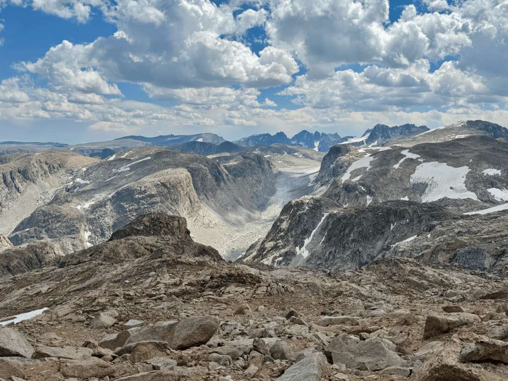
After the steep descent from Douglas it’s a long and slow way through Alpine Lakes. Very beautiful though. Once I reached Upper Alpine Lake I had to do a long scramble on the west side in order to reach the base of Alpine Lakes Pass. This was extremely time consuming and tedious. It required some class 3 scrambling and a couple times I got cliffed out and had to go back up. Frustrating. The route around the lake was more difficult than the pass itself. On the other side of the pass I saw the first glaciers of the route, Bull Lake and Knife Point Glacier. The six mile section from Alpine Pass to Blaurock Pass is quite spectacular. Hard to put into words, hopefully you just look at the pictures and videos because I don’t think my vocabulary would do it justice. The approach to Blaurock had me walk across a large floodplain. I put my socks in my pocket and went barefoot in my shoes. I took my dinner break before the huge climb and chatted with a couple who were there peak bagging. I ate a Peak Refuel and threw in some cheese and Fritos, well over 1,000 calories and I needed every last one. Blaurock Pass is the steepest climb for NOBOs on the WRHR. From the bottom it’s 1,860ft in 1.1-miles as the crow flies. The climb up took me two hours, much slower than expected. The peak was insanely windy so I started going down immediately. When I reached the bottom (Dinwoody Creek) I saw a huge group of hikers there. Maybe 4-5 tents. That sucks because there’s not many flat spots in the area. I ended up fording the creek and pitched my tent one foot from the trail. Not the flattest spot but it’s nice and soft. Ended the day around 8:15 which I think is the latest so far. Tomorrow should be my last full day.


Day 5: 22 miles
Only got a few hours of sleep last night. Oh well. Got moving by a little after seven and it was straight up West Sentinel Pass first thing. Pretty quick and easy climb. At the top I was immediately greeted by Gannett Glacier. The first hundred yards or so was very slippery but luckily it didn’t last long. This was the first time I ever hiked on a glacier so I can check that off the bucket list. Then came the climb up to Iceberg Lake Pass. This one was kinda weird, you had to climb above it and then down to it. Skurkas map says to descend the east side but I disagree. I went down the west side and it wasn’t as steep, no snow, and you had great views of Iceberg Lake and Baker Lake. After the pass is when the day turned on me. This entire section is completely exposed, no cover from the elements at all. The winds were very strong out of the west the entire day, at least 25mph. That just really ruined hiking for me. I got on the wrong side of a ridge and had to make my way back over it. As I went down a rocky mountain I really busted my ass bad. Very greatful I didn’t get injured. I had one last objective which was Downs Mountain, the last climb for NOBOs. It’s a one mile ridge that’s all boulder hopping, a fitting way to end it. As I approached the ridge the winds picked up and the clouds to the west were dark. I started getting pelted with rain and the wind was strong enough to knock me off balance. I made it to the beginning of the ridge and found a wind block and hunkered down for a bit.
After about fifteen minutes I started making my way up keeping a watchful eye on the weather. I stayed to the east of the ridge to avoid the wind. I was 400ft from the summit when dark clouds rolled back in. I found another spot to hide and waited as I heard the sky rumble above me. I took the time to write this while I sat there. I got a little bit closer and was 275ft from summit when dark clouds again rolled in, terrible timing. The sky was rumbling so there was no way I was going further, I again found a spot to sit and wait. I grew impatient and crept forward. I got to what I thought was the summit but it wasn’t, wtf. I hauled ass to the real summit and hopped up there real quick and the wind immediately blew my hat and sunglasses off. That’s a sign I need to gtfo. On the way down there was a woman going up, I couldn’t believe it. We talked for a couple minutes and parted ways, hope she made it. On the way down I busted my ass again and then found a nice flat spot for dinner while the storm rolled over.
The route in this entire last section is completely wide open. I could not find any good spot for a non-freestanding tent so I wanted to get back to trail. After No Man’s Pass it’s a long walk through Goat Flats. As the name suggests it’s as flat as a board but littered with rocks and still windy. I put my head down and grinded through it. Eventually I started descending down to the trail and I could see that it wasn’t in the tree line. I was tempted to go all the way to the trailhead but it was getting dark and I was exhausted. I reached the Old/New Glacier Trail junction and went into the tree line to the west to escape the wind. Quickly set up my tent before darkness and hopped in. Today was the worst day on the WRHR. I wasn’t a fan of this last section due to how wide open it was. It reminded me of the desert which I hate. On top of that the wind was just horrendous and the storms right as I was ascending Downs Mountain were frustrating. I’m glad I only have a few miles tomorrow


Day 6 & Post Hike
Enjoyed my final trail breakfast and started hiking at 7:30. I had two options going down to Trail Lakes, the 801 or 801.1 trail. The latter is shorter by a couple miles so that’s the one I took. I enjoyed walking a trail after the last two days of off trail travel and cruised my way down to the end by 9:15. Officially done with the WRHR at 4 days, 23 hours, and 15 minutes. I guess I could call it five days but it’s nice to know I did it in under five.
The issue from here is I was two days early for my scheduled pick-up on Saturday morning. I knew I was gonna finish early by day three and decided to just eat the cost of the shuttle ($85) and figure it out when I got there. The only option was to begin the thirteen mile road walk into Dubois. Unfortunately most of the traffic that early is going in the opposite direction but I lucked out around 11AM when a truck pulled over and offered a ride. Can’t say no to that. It was a woman from the area who was familiar with thru-hikers.
I got to town and immediately hit up the coffee shop for a cold brew and a doughnut. Then I went across the street to The Fluffy Cow and holy shit these guys make epic hiker food. Humongous portions and they give hikers a 20% discount. I had a huge sandwich with fries and homemade dipping sauce. This food put me into a coma and I was full for most of the day afterwards. While I was there I contacted Dubois Shuttle and scheduled a ride to the Jackson Hole airport the following day. It cost $175 but it’s a three hour trip for them. According to their website they are a local husband and wife couple who offer rides when available. I bought my plane ticket home while in my food coma. It was $400 back to Maine with a layover in Chicago. This was a FAR better option than flying out of Riverton which was the original plan. I saved hundreds by finishing early and not going back to Lander. Much cheaper flying out of JAC. With the travel plans figured out I spent the rest of the day doing laundry, eating, and stayed at the free church in town.

TRIP REPORT & GUIDE
ABOUT THE WRHR: The Wind River High Route is a 97-mile route created by Andrew Skurka. It offers some of the finest scenery in North America and requires some of the hardest hiking in order to witness it. In short, you get what you work for. You will hike steep passes, steep mountains, glaciers, meadows, rock-hopping, floodplains, and almost everything in-between. Only 1/3 of this route is on trail with the remaining 2/3 off trail which requires route finding, navigation, and much slower travel. There are currently two versions of the WRHR, the Skurka version and the Adventure Alan version. It’s universally agreed upon that Skurka’s route is the more challenging of the two. It’s about twenty miles longer, takes higher routes, and has much more elevation gain. That being said they both overlap in certain sections and both are challenging routes that is not recommended for beginners. You will spend almost the entire 97-miles well above 10,000ft as you follow the spine of the Wind River Range
RESOURCES: The main resource as you can imagine is from Andrew Skurka’s website. His WRHR bundle costs just $25.00 and is a must have. I also looked at the many available trip reports online which provided more context and was nice to read different opinions.
WEATHER: I lucked out and had incredible weather. The only hiccup was the last day where there was high winds and a couple thunderstorms going up Downs Mountain. Aside from that I had sunny clear skies and not a single drop of rain. Do not expect to get as lucky as I did. The Wind River Range is notorious for nasty storms that can get bad. I’ve been to the Winds three times and this was the only time I didn’t face a bad storm. On this route you will be high and exposed often so you need to pay attention to the skies. It’s also not uncommon to get snowed on even in the summer, some hikers have had to spend most of the day inside their tents because of it.
NAVIGATION: Included in Skurka’s bundle is a GPX file that I uploaded to Gaia GPS. From there I used the NPS map which I find is one of the most detailed. The GPX file only includes trailheads, the main checkpoints, and alternates. The main route of travel along with his notes are only found on the map-set. I printed these out (8.5×11) and carried them as back up. I also had them uploaded into my iPhone and referenced them everyday.
WATER: Water isn’t really an issue. I only had the capacity to carry 2.5L and the most I did carry was 2L and that was only for camp and into the morning for breakfast. Some of the water you find will be murky, not everything is as crystal clear as you think it would be.
WATER CROSSINGS: I did not encounter any major fords and it’s unlikely you will unless you hike very early in the summer which is not recommended. My feet were mostly dry during this trip.
GRIZZLY BEARS: The grizzly population is not strong in the Wind River Range. Recent reports show that the entire state of Wyoming only has around 1,000 grizzly bears and most of them are located in the Yellowstone and Grand Teton range. It is rare to see a grizzly in the Winds. The northern section of the route near Dubois is will the greatest chance of encountering a grizzly bear.
BEST SEASON: August and September is the recommended time. June and July is possible but lingering snow will be an issue. This route won’t take more than 10 days so might as well pick the best weather window.
WHICH DIRECTION: I went northbound. Going NOBO is the recommended direction of travel. It begins much slower in terms of climbs and the first 14-miles is on nice maintained trail. The only downside for NOBO is the first climb is the biggest of the whole trip in terms of elevation gain, around 2,500ft up Wind River Peak. But what comes after can be more challenging, the West Gully. The West Gully is a very steep section of trail that’s all on loose ground. Going north you will be descending the West Gully which can be sketchy. Going up the West Gully would be more safe. Going SOBO you will only be on trail for 6-miles before going off trail and immediately climbing thousands of feet of elevation with a full pack
GETTING TO TRAIL: I’ll write this from the perspective of hikers without a vehicle because that’s how I did it. It will obviously be easier if you have one or even two cars. Going NOBO I flew into Riverton, WY and took a cab to Lander. From there I paid $20 for a ride from Wind River Shuttle to Bruce’s Bridge TH. I also prepaid them $85 to pick me up a week later. As of this writing they offer three shuttles a week on Monday, Thursday, and Saturday. The way they operate is they pick you up at the northern terminus (Trail Lakes) at 8AM sharp and drop you off at the southern terminus (Bruce’s Bridge) at 10AM. Along the way is when they picked me up in Lander in front of the Safeway. Many hikers with cars will simply arrange that shuttle and then hike NOBO back to their car. As of now I would recommend this method if you wish to start at Bruce’s Bridge.
If your goal is to start SOBO at Trail Lakes then you will fly into Jackson Hole and you can rent a car or arrange a shuttle pick up. I used Dubois Shuttle to go from Dubois to Jackson Hole airport which cost $175. The people who run this shuttle are a husband and wife combo so their availability will be limited with their work schedule. You definitely want to arrange ahead of time for a pick up. They would also be able to drop you off at the trailhead.
https://www.windrivershuttle.com/
https://duboisshuttle.com/
GOING HOME: I was originally gonna get a ride back to Lander with Wind River Shuttle but I finished two days early and decided to eat the cost of the shuttle and just go into Dubois. My recommendation is to just do the 13-mile road-walk into town. The walk is about 10-miles on a dirt road and 3-miles on a paved road. If you can complete the WRHR then a 13-mile road-walk won’t take you more than 5-hrs. The trailhead is a popular one so it is possible to get a hitch. I only walked two hours before a truck pulled up and offered a ride. If you pre-arrange a shuttle like I did then that means you must meet them at the trailhead at 8AM on either Monday, Thursday, or Saturday. I planned on hiking from Saturday to Saturday but got ahead of schedule. I personally regret paying for the shuttle but at the time it seemed like a good option. When I got to Dubois I paid $175 for a shuttle to the Jackson Hole airport the following day.
If you finish at Bruce’s Bridge then it’s a 10.5-mile road-walk to Lander main street, all on paved road. If it were me I would do the road-walk, worst case scenario you walk 3 to 4 hours, best case scenario you get a hitch. You could also probably get a ride with Wind River Shuttle when they drop off hikers at 10AM on Monday, Thursday, or Saturday.
Note: I don’t recommend using the Riverton airport. That airport only offers one flight in-and-out of Denver, that’s it. It was surprisingly expensive when I looked up tickets for a potential flight home, around $700-$1000 with only one layover. That was a weekend price but even the weekday was pushing $600. When I flew out of Jackson Hole on a Friday it was $400 with one layover.
ELEVATION: The elevation is a very real problem. For almost the entire 97-miles you are above 10,000ft and there are several instances where you will be over 12-13,000ft. Elevation sickness is a very real possibility and you need you have a plan going in if you are coming from much lower elevation. Many hikers have had to call it quits on the WRHR due to elevation sickness. For me I live at sea level in Maine, 40ft to be exact. For this reason I hiked the northern half of the Great Divide Trail to get myself acclimated to elevation. The highest point on that trip was 8,500ft so it was a perfect warm up. I understand most people won’t have the time for this option so my recommendation is to travel as early as you can so you can at least spend 2-3 days in Dubois (6,950ft) or Lander (5,350ft). That’s really the only option if you’re limited on time and live at low elevation. I highly recommend learning about the signs and symptoms of elevation sickness (AMS/HAPE/HACE) and not only recognizing them but how to treat them. It might even be worth it to get a prescription of acetazolamide (Diamox) and/or dexamethasone from your doctor. You cannot buy them over the counter. There also isn’t an easier starting point in terms of elevation. Going north you will summit Wind River Peak (13,197ft) 17.5-miles in. Going south you will summit Downs Mountain (13,355ft) 14-miles in.
PERMITS: There’s only one permit you need which is the Tribal Fishing Permit. You need this when you enter the Wind River Indian Reservation in-between Photo Pass and Europe Pass. I got this permit at the Wind River Outdoor Company which is a large outfitter in Lander. Unfortunately, this permit cost $60 which was way more than expected. What makes it annoying is the section you need it for is only about six miles. I wouldn’t be shocked if a lot of hikers don’t pay for it due to it’s price tag. After all there’s nobody out there checking permits. It’s a choice I leave up to you.
RESUPPLY: The main resupply strategy is simple, carry all your food from start to finish. This route is only 97-miles and it’s truly in the middle of nowhere, after all it’s a high route. That means access to roads where you can go into town is not easy. If you average 14-miles a day you will finish this route in seven days, a seven day carry isn’t bad and should be capable for anyone willing to attempt this. If you want to add another day to it then all you need to average is just over 12mpd.
As far as calories go that is very subjective, my only recommendation is to carry a little bit more than usual due to the harsh demands of the route. Off trail travel and steep climbs take a different kind of toll on your body, you will burn more calories than walking on a easy well built footpath. Another factor is the weather, it’s not uncommon to be held up due to a bad storm which means it could slow you down by half a day or more. Because of all that I recommend increasing your calorie count by at least 10%. I normally carry 3,000 calories a day and for this trip I took almost 3,500 a day, so about a 15% increase. I started with 24,000 calories for the planned seven day trek.
Here’s a list of all the food I carried
– 7 dinners (3 Freeze Dried / 4 Rice & Beans)
– Fritos
– Snickers x14
– Cheese
– Dark chocolate
– Kodiak Oatmeal x12
– Trail mix
– Planters peanuts
– Pro Bars / Kates Real Food / Hornby
– Coffee & LMNT
– Multi Vitamin/Fish Oil/Creatine/Iron/Ashwagandha
ALTERNATES: The alternates on the WRHR are different than the alternates on a long trail like the PCT or CDT. Alternates on those trails tend to be either physically harder, more scenic, or both. On the WRHR the alternates are lower routes if the weather is bad or if you’re simply not feeling it that day. I lucked out with weather and was able to follow all the main check points and did not take any alternates so I can’t tell you what they’re like. I would highly recommend sticking to the main route unless the weather is truly apocalyptic. I notice a lot of hikers will find an excuse to take a lower alternate even if the weather is perfect. Just take a good break and stick to the main route, you’ll be glad you did and there’s a chance you might not even attempt the WRHR again.
GEAR: https://lighterpack.com/r/xwxn02
I did this route immediately after the Great Divide Trail so I used the same exact equipment. The only difference being new shoes and no bear spray. Everything worked well so there’s nothing to note.
RECOMMENDED GEAR
1. A good all-weather Gortex jacket. I got lucky with the weather but the Wind River Range is infamous for it’s severe weather. That includes fierce winds, cold temperatures, scary lightning and thunder storms, hail, rain, and even snow. In rare cases you will get all of that at once. I’m not saying the typical ultralight jacket won’t work but I just don’t recommend it. I carried my Arc’teryx Alpha FL jacket that weighs just 10.5oz and have no regrets. This is one of those things you’d rather have and not need than need and not have
2. Garmin InReach Mini 2 or similar. I don’t think I need to explain this much. This route is almost 70% off trail and not heavily traveled. Combined with the aforementioned weather and steep rocky terrain you could easily find yourself in a bad situation needing rescue. I also can’t tell you how many times I was rock hopping and stepped on a large boulder that was very loose. The movie 127 Hours was on my mind a lot. If you are hiking in a group and only one person has a PLB then that would be fine, but if you hike solo like me then it would be dumb not to carry one.
3. A storm worthy tent. Have a tent that you trust and can stand up to bad weather much like what I said with a good rain jacket. The last thing you want is you tent falling apart in the middle of the night.
4. Trekking poles. There are some very steep descents on loose gravel. I was very glad to have four points of contact when going down those.
FINAL THOUGHTS: The WRHR was hard but it wasn’t as hard as I expected. I heard so much about it that in my mind I envisioned the worst. The X-factor here is that by this point I have around 12,000-miles hiked with a decent chunk of it in rough terrain, off trail, and high routes. I also take physical fitness very seriously when I am home so that plays a major role. I would absolutely not recommend this route for a beginner backpacker, that would be a bad idea. That being said you don’t need to be a seasoned thru-hiker to complete the WRHR. If you have off trail travel experience (especially in high routes), time spent at high elevations, and you’re in good shape then you shouldn’t have too much trouble on the WRHR. A good alternative would be the Alan Dixon route (Adventure Alan) if you’re concerned Skurka’s route would be too much.
I felt like I was well prepared to take on this challenge as a solo hiker. I had a great warm up on the Great Divide Trail to get my hiking legs and to more importantly adapt to high elevations. I also read everything in Skurka’s guide multiple times. Every night in my tent I would look ahead to the next days terrain and climbs. I spent a lot of time studying the maps and I also read as many trip reports from prior hikers as I could. In fact my main motivation for this write up is to provide another source that might help others.
