
2024 – Section A/B/C (Waterton to Field)
TRIP DURATION: July 29th to August 12
LENGTH: 337 miles
ZERO DAY: Banff (August 9th)
DAYS WITH RAIN/HAIL: 6/15
BEAR SIGHTINGS: 1
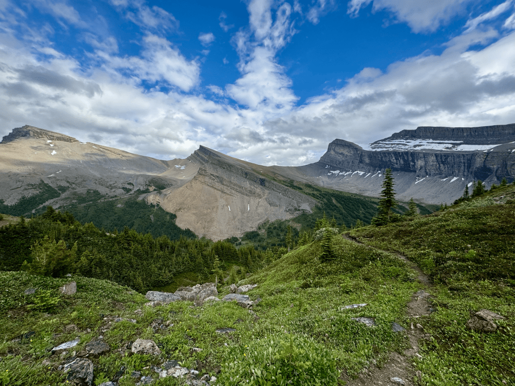
Day 1: 17 miles
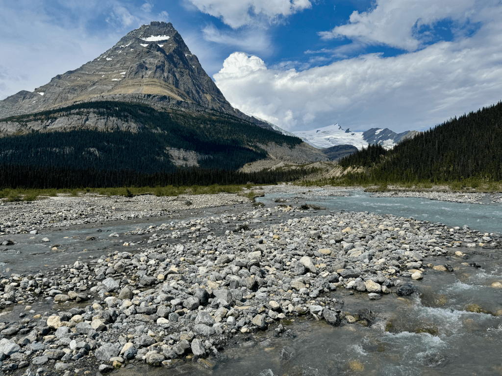
Got to Waterton at 1AM and camped at an empty spot at the campground. Only got a few hours of sleep before packing up at 7AM. Stopped by a coffee shop for a quick breakfast before buying some bear spray and a fuel canister. Apparently there were no small fuel canisters sold in town, they only had the medium and large ones. From there I hiked four miles SOBO to the border where the trail officially begins. This was the first time I ever reached this terminus even though I’ve been to Glacier NP three times before. Nice to finally see it. The 6.5 mile climb to Carthew was slow but the trail was nice. I saw probably a dozen people which was surprising. The last 1.5 felt never ending, many false summits. I got to Akamina CG around 6:45. Much earlier than I like to stop but that’s how it is on the GDT. All the tentsites were on gravel which meant I couldn’t pitch my freestanding tent. Had to find another spot on the dirt somewhere. This was a pretty windy campground. The ground was pretty soft so I hope my stakes stay in. My iPhone says I walked 29.5 miles today, I estimate it was probably around 25. However only around 17 of those miles counted toward the trail

Day 2: 21 miles
Woke up at 6am. It rained last night so I’m glad I didn’t cowboy camp. Started the Rowe alternate at 7:30. It’s about 1,700ft gain in 1.3 miles, but the last 0.6 has 1,300. Took me 80-minutes to get to the top, I didn’t think it was bad. There are worse climbs on the Appalachian Trail if you ask me. The ridge walk was wide open, great views. The worst part was going up Festubert. Dark clouds rolled in and there was very loose scree going up. Insanely slow. Got to the summit and then the rain came, I went down as fast as I could but it only lasted 20-min or so before it cleared up. It took me 7hrs and 15min to do this 11-mile alternate. Slow going but I highly recommend if weather is good. I got back to the main route around 3PM. From there it was only 9 miles to my planned campsite (Scarpe Pass). It was nice to be back on a trail after all the cross country travel. I took a long break around 5PM to cook dinner since I had time to spare. Got to the campsite at 7:45. It feels strange to be forced to end my day early, especially with daylight until almost 10PM. But it was a pretty long day for only 21 miles so I’ll take the extra rest. I also realized this morning that I miscalculated how much food I needed for this section. I currently only have 4,800 calories remaining with two more days of hiking. I usually want to have at least 3,000 per day. Unfortunately this means I probably won’t be able to do Barnaby Ridge like I planned. That alternate is tough and slow going so I would definitely run out of food

Day 3: 29 miles
Didn’t fall asleep until after midnight. This year I’ve been finding it very difficult to sleep on trail. Woke up at 5:48 and got moving by 6:15. I had a tough three miles to start the day going up to La Coulotte. At the summit is the beginning of the Barnaby Ridge alternate. I had planned to do it but I did not pack enough food for this section. There’s a good chance I would run out of food if I did this slower moving route so I continued on the main route down towards Castle Mtn Campground. It was an extremely slow moving morning. Tons of ups and downs. However the good news is that the rest of the way was not only downhill but much of it was dirt road. I made it to Castle Mtn a little after 3PM. They had some snacks there so I ate two small bags of chips and drank a 16oz Coke. Many athletes actually drink Coke during their competition because it has easy carbs, sugars, and caffeine to keep you going. I sometimes drink a 7.5oz Coke before long runs. So that 16oz really hit the spot and was exactly what I needed for the rest of the day. They had WiFi there and I found out Jasper NP canceled all my permits due to the wildfires. I guess that means I officially won’t be able to thru hike the GDT. Oh well. Hopefully I can do sections A, B, and C since that would be half the trail. Leaving Castle Mtn it was a quick 3.5-mile paved road walk back to trail. From there all I had was a 1,200ft climb and it was smooth sailing to Lynx Creek CG. The last half of the day only took me 8-hrs to do 22-miles compared to the beginning of the day which took me 6-hrs to do 7-miles.

Day 4: 20 miles
Got moving around 6:30. Nothing significant today aside from a PUD (pointless up and down). Took the alternate route into Blairmore because that’s where all the grocery stores are at. Got in around 12:30 and went straight to a cafe for a late breakfast. From there I got my next resupply at three different stores. The IGA had a poor selection in my opinion, I got a better resupply at the Circle K next door. Walked about two miles down to Coleman and got a room at the Paddock Inn for $130CAD. It’s the standard cheap motel, nothing fancy but it’s on the Main Street. I did laundry and went to The Rum Runner Restaurant and Pub down the street which had very good reviews. There was a line out the door when I arrived and two women in front of me offered to let me sit with them so I did. I was honestly hoping to sit at the bar and watch sports but whatever. They were both from Canada and we talked about a bunch of random things to kill time. The food took a long time to come out because it looked like there were only three chefs. I had a HUGE double patty burger that really hit the spot. Definitely need the calories. One of the women went out for a smoke and came back with a very intoxicated man. This guys face was as red as I’ve ever seen before and I’m Asian. So now I’m sitting at a table with three complete strangers devouring my burger. Interesting situation to say the least. After that I went back to my room to take my second shower and then type this all up. Town days go by too fast. It took me about five hours from the time I got into Blairmore to checking into my room. I’m tempted to zero but I can’t since my hike got delayed due to my flight getting canceled. That means I started a full day behind my permit itinerary which is one of the annoying things about that whole system
Day 5: 21.3 miles
Slept well. Woke up at 8 and went across the street for breakfast. Had a very good chorizo, egg, and rice skillet. After that I went back to my room and chilled out until my 11AM check out. I never leave before check out on trail. There was a free can of Pepsi in the fridge so I drank that before I headed out of town. The first 8-miles kinda sucks. Just road walking combined with following a path made for dirt bikes and ATVs. When the trail picks up it’s pretty great. It’s a recent addition to the GDT called the High Rock Trail. Well built and marked, must have taken years. I think it’s around forty miles so I will enjoy it. There were many ups and downs today which made for slow travel. Made it to Window Mountain Lake CG by around 7PM but I just filled up water and kept going. I honestly kind of regret it because that was one of the best campgrounds I’ve seen so far. There were a bunch of people there also which wasnt surprising since it’s Friday. I’m always jealous of people who hike in groups, it would be more fun and nice to have someone to talk to. Hiking solo sucks on a trail like this. I did a few more miles and stopped at a random spot next to a dirt road at 9PM. My original goal was First Creek CG but I fell 2.5 miles short, oh well. I also realized there’s no way I will make my reservation at Porcupine CG in four days. I would need to average almost 38mpd. My delayed start really screwed up my itinerary but I’m not sure if I would’ve made it anyways.

Day 6: 28.2 miles
Last night wasn’t fun. I kept on hearing loud noises coming from the trees not far from my tent. Sounded like something big was moving in there. It even caused a tree to fall over. Obviously I didnt sleep too well. I never saw what it was though. I started hiking at 6:30 with bear spray in hand until I was a mile or so away. The day was pretty boring until late noon. That’s when I started the climb up Tornado Saddle. The last half mile or so is super steep. Doesn’t help that it’s all loose scree so you take one big step only to slide back down. The Saddle was very windy but had some nice views. On the decent I took my dinner break at a water source. Had some nice ramen noodles. I don’t remember the last time I ate ramen. After I ate it I drank the leftover broth. It had around 1,800mg of sodium which I needed. I also had two packets of LMNT today so I’m well over 4,000. Ended up hiking until 8:45 where I found a great tent site on a ridge. Overall it was a pretty tough day. Lots of ups and downs. On a trail like the CDT I’d probably be at 35 miles
Day 7: 27 miles
Started moving at 6:30. Nothing really happened until 10:45 when I had a grizzly encounter. I was going uphill and when I looked up I saw a grizzly standing there. I immediately made noise and it went away. He/she was probably 40m away. I hiked the next couple miles with bear spray in hand and doing frequent bear calls. The trail was very nice today. It reminded me of the Appalachian Trail believe it or not. It was a green tunnel with nice tread and blazes to follow, only these were orange. At around 1:30 it started raining so I had to throw on my jacket and pack cover. Found a nice tree that was dry underneath to take cover. Lucky for me the rain ended at 2:20. I stopped at Lost Creek Campground at 5PM for dinner. There were three other people there and it was nice chatting with them. As I left at 5:30 it started to rain again. I threw on all my rain gear and headed out for five more miles. The rain was pretty steady and I had one good hill to climb. I had to do an open ridge walk up top and I went through that as fast as I could. I didn’t want to get struck by lightning. I made it to Cataract Creek Campground at 7:30 and called it an early day. It really sucks setting up a tent in the rain, I don’t remember the last time I did it. I got a surprisingly good pitch and got in ASAP. It was nasty taking off all my wet clothes inside the tent but I knew I’d be in my dry sleeping bag soon. I usually bring my pack inside with me but this time I’m leaving it in the vestibule. Everything is soaked pretty good. Im laying in my bag as I type this, my shirt still a bit damp. I’m really hoping it’s not raining in the morning
Day 8: 33 miles
Got up at six and everything was soaked, but at least the rain stopped. Packing away everything wet is always miserable but you have to do it. Made coffee and got moving by 6:30. Pretty standard day with some ups and downs. Around noon time I went up to Fording River Pass which was awesome. Wide open alpine for about a mile. From there it was all downhill the rest of the day. I came by a cabin at 1:45 and nobody was home. I’m guessing it was a ranger cabin. I took a long break to dry everything out and sit in some lawn chairs. I brushed my teeth, got a good stretch in, and found out some toenails are coming loose. Nice. Packed up at 2:30 and got moving. Would’ve been nice to sit longer but I had a big day planned. I hiked for the next 3.5-hrs nonstop. All but two miles of it was on a dirt road. I was actually excited for a road walk after all those ups and downs. Nice to put in some easy miles. I made it to Tobermory Creek CG at 8:45 right as a storm was rolling in. I set up my tent and quickly got in. Within minutes a massive hail storm came over me. It was pretty intense. So glad I made it in time.
Day 9: 25.2 miles
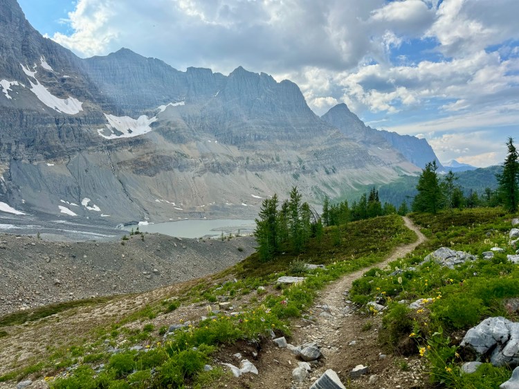
It rained and stormed really good last night. Decided to make coffee in the little cabin and eat my breakfast there (a 350 calorie bar). Got moving by seven and made it to Elk Lakes a few miles later. Great views, there were many tents. From there it was an easy trek to Elk Pass where I picked up my resupply box in the bear lockers. There was suppose to be a combo lock on my bin but there wasn’t. Thank god nothing was stolen, that would’ve really fucked me over. I took the time to dry out my tent, brush my teeth, stretch, and reorganize my food bag before leaving. My original plan was a short day to Aster Lake CG but the Northover Ridge Alt was only 15 miles and I had almost 10 hours of daylight remaining so I decided go for it. The walk around Kananaskis Lake was easy and very scenic. Then I started the climb up to Aster Lake. There was a one mile section that was rough, very steep and on loose rocks. When I reached the campground I was amazed at how nice it was. It was rebuilt so everything was new. Might be the best campground I’ve ever seen. I wished I could’ve stayed there but it required a permit. From there I had 7.5 left of Northover Ridge but I hadnt even gotten to the ridge yet. It was a slow and scenic climb, some of the best views I’ve ever seen. The ridge is notorious for its “knife edge”, I read a lot of comments saying “dont do it if you’re afraid of heights” among other things. When I got to that section I realized it was all fear mongering. It wasn’t much of a knife edge at all, not to mention it was less than half a mile. It was still fun but not as “sketchy” as people made it out to be. From there I descended down to Three Isle Lake CG, made it there by 7PM and called it an early day. The campground was like a maze of tentsites. I ended up meeting two other GDT NOBOers, first ones I’ve seen who weren’t section hiking. I ate dinner with them and it was nice to talk to people for a change. I devoured my Peak Refuel dinner and found a nice tent spot tucked away in the corner

Day 10: 26.5 miles
Rained again last night. Foggy and wet in the morning. Got moving by 7AM and I made the mistake of not putting on rain pants. Within the hour my legs were soaked walking through all the wet brush. Didn’t help that it was cold out. To make matters worse it started raining on me, my pants looked like they were dipped in water. I threw on the rain pants and pack cover, better late than never I guess. Due to being cold, wet, and miserable I took almost no breaks from 7-3 aside from brushing my teeth for a few minutes at Palliser River. I didn’t even take my morning shit until around 3:30. The sky finally cleared up late afternoon when I entered Banff NP. The last 4.4 miles of the day was on great national park trail, this is obviously where I started seeing more people. I made it to Marvel Lake CG around 7PM and quickly set up my tent because it started sprinkling again. I actually hiked the whole day wearing my Arc’teryx hardshell jacket. One of the best gear decisions I made was bringing legit rain gear. I made my way over to the food prep area (which was kinda far from the campground) to make dinner. Tonight it’s Peak Refuel Creamy Peaches and Oats. Today went by extremely fast, before I knew it I was only a few miles from camp. It’s probably because I hardly looked at the time for the first half of the day getting soaked. I’m also hiking less hours than I normally do. Today was only 12-hrs (7-7), I usually do 14-15-hrs on trails that don’t require me to stay at campgrounds

Day 11: 24 miles
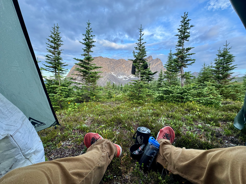
This morning was like my mornings on the Appalachian Trail. Got up at 6:40 and didn’t leave camp until I drank my coffee, ate breakfast (pro bar) and took a shit. I usually do those things after I start hiking. Because of all that I didn’t start hiking until 7:45, one of the latest starts I’ve had in a while. I immediately started going up Wonder Pass, it took about 5-miles. The pass was beautiful as expected. From there it was a couple miles to Lake Magog. It’s a short side trip to the lake that should honestly be the main route. It’s one of the most scenic lakes I’ve ever seen with a huge backdrop of the Rockies behind it. Took a good break there of course. I had around 16-miles until Sunshine Village so I started moving at 11:30. I went up Citadel Pass later in the day which was just as beautiful as Wonder Pass. I made good time and got to Sunshine Village at 6PM. I immediately went straight to the restaurant (Trappers) and ordered burger and fries. My first town food in a week. I had a bit of an issue though. There’s no campground near the village and the only lodge is over $300cad. Hell no. There is a gondola that can take you down to a free bus to Banff but apparently they stop running at 6PM. Bad timing. So my only option is to stealth camp near the village. Obviously not the best option but I didn’t know what else to do

Day 12: 0 miles
Woke up around 7:20 and quickly made my way back up to Sunshine Village. Went into the little coffee shop for a quick breakfast. From there I bought my gondola ticket ($70) and headed down the mountain. Hopped on the free shuttle and twenty minutes later I’m in Banff! I was here last year when I was a firefighter and they sent us to Alberta to assist in their fires. Weird to be back. As my luck would have it I arrived on Friday which meant the average price of hotels were $500/night, seriously. My original plan was to take two nights in Banff but due to the price and the fact that I only have 65 miles left it’s only one night. I stayed at the Elk + Avenue which in total cost me $568. It’s located in the middle of town and across the street from the IGA. After check in I went for a real breakfast and to do my quick resupply. I had much food leftover so I didn’t need much. Went to Monod Sports to buy two Peak Refuels and then a quick stop at the IGA for a few bars and I was done. Went back to the hotel and did shower and laundry. For dinner I went to an Italian restaurant and had chicken parm, really hit the spot. I could see the movie theater from the restaurant and decided to check it out. They were showing Deadpool and Wolverine at 7:10, I looked at the time and it was exactly 7:10 so I decided why not. This is the first time in over ten years that I’ve been to the movies. It’s been a while. I liked the contrast of being in the woods alone for 11 days straight and now I’m in a movie theater with a bunch of people. The movie was good, went by fast. Headed back to my room at 9:30 and took another shower and watched TV. Wish I had more time to enjoy this town
Day 13: 12.7 miles
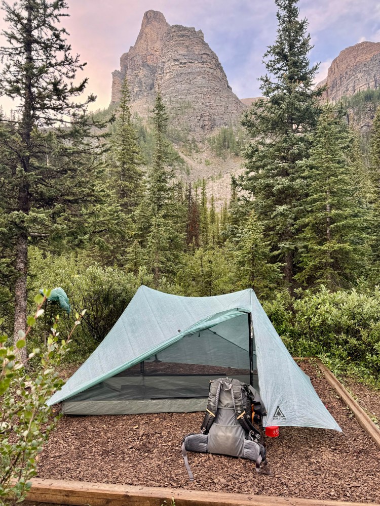
Woke up at 8 and went down the lobby for breakfast. After that I got a coffee next door and chilled outside for a bit before going back to my room for one last shower and packing up. The bus is scheduled for 11:21 next door so I had some time to kill. Went to IGA and got a Bai Coconut drink. Made it back to trail by 12:30 and from there it was easy going. Went up Healy Pass which had great views. On the way down I got hit with a huge hail and thunder storm. But lucky for me I came across a shelter where I could take cover as soon as it began. Perfect timing. The temperature really plummeted during the storm. There was a thermometer on the shelter and it read 46°. I’m lucky I only had 13-miles to do and only 5.3 from the shelter. It was only 4PM so I had time to wait out the storm. I figured it would be a good idea to cook an early dinner since I wasn’t doing anything and I was getting cold. I rehydrated some Peak Refuel and it felt great eating something hot. So glad I brought a stove on this trip, first time since 2015. The rain died down a bit so I started hiking at 5PM. Spent almost two hours at the shelter. Almost immediately I start going up Whistling Pass and I see many people on the way down. Looks like they had to find cover up there during the storm, they didnt look happy. Some light rain started on the way up but I just put my head down and kept going. I definitely missed out on the views but it is what it is. The trail went by Haiduk Lake which looked nice even in the storm. Lucky for me it really cleared up after that and I had good weather all the way to Ball Pass Campsite. Got there at 7:10 and that was the only campsite on this whole trip that I had the correct permit for. I only got it because someone on the Facebook group offered it to me while I was in Coleman. Otherwise my original permit was the day before. I took campsite #2, set up my tent, put my food away in the lockers, stretched out a bit, and got in the tent.
Day 14: 25 miles
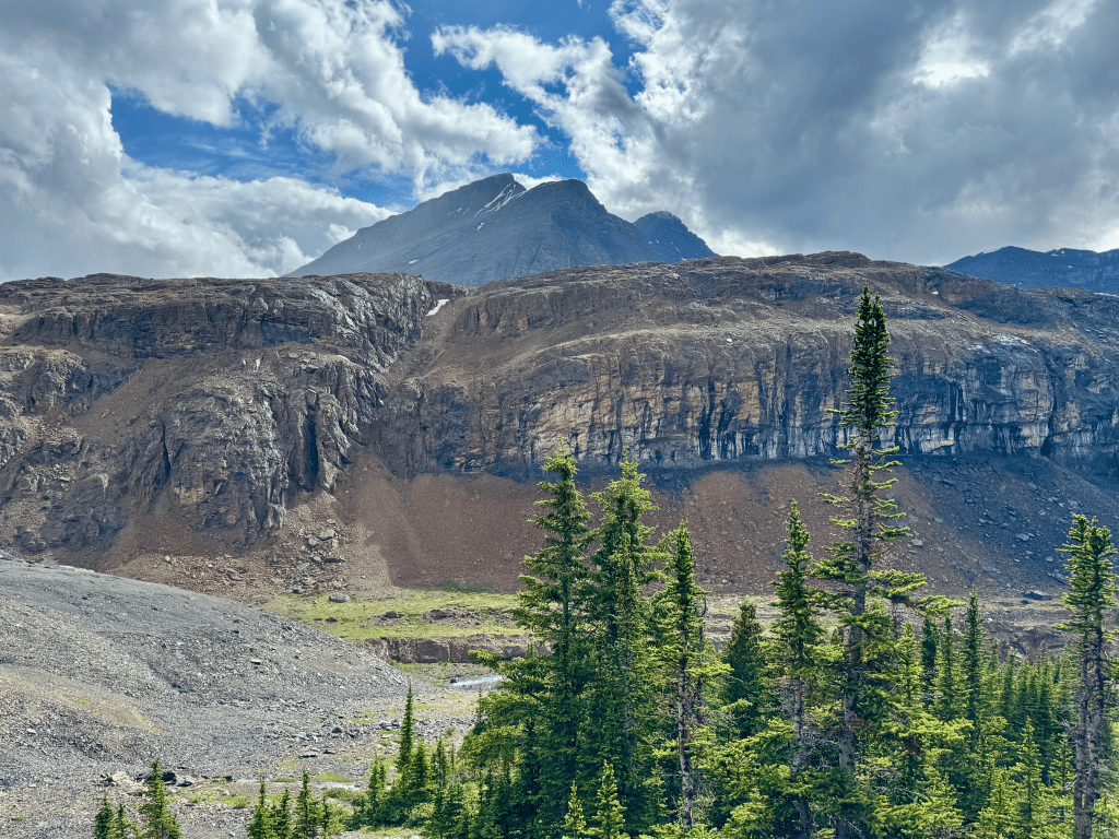
Up at 6, cold and wet. That’s what happens when you camp at the lowest point. Started moving at 6:40 and it was a quick climb up Ball Pass. From there it was all downhill but super wet from all the brush. Made it to Floe Lake TH at 9:45 and took a long break. The parking lot was jam packed on Sunday morning. I made another coffee, ate a few snacks, and dried out some gear before leaving at 10:30. It was a six mile climb to Floe Lake CG, got there at 1PM. This is one of the most popular campsites along the GDT and in Banff. Floe Lake sits in front towering mountains. Getting a permit here is almost impossible unless you’re early. I won’t be staying here but I took a long break, dried out my tent and sleeping bag, made a LMNT drink, and brushed my teeth. Started moving at 1:50 and it was about a mile to Numa Pass. Great views as expected. From there it was four miles all downhill to Numa Creek CG. As I got to the CG it started sprinkling on me. I noticed dark clouds rolling in so I took a quick break and started going again. It was only 6.3 miles to camp and 3 miles to Tumbling Pass, I didn’t want to have to wait out a storm. Lucky for me the storm wasn’t headed my way and I ended up having good weather the rest of the day. Tumbling Pass had some incredible views just like all the other passes today. On my way down I made a quick dinner and then pushed onto Wolverine Pass. It was a quick climb compared to the others with equally good views. Wolverine Pass is popular among thru-hikers because 0.1 west of it you leave park boundaries, which means no need for permits. I got there at 7:30 and found a nice flat spot. The ground was nice and firm which meant my stakes went in smoothly and I don’t have to worry about them coming out, always a plus. Today was my biggest day in terms of elevation. I gained and descended around 8,000ft each over four different passes.
Day 15: 28 miles
Woke up at 6 and started moving at 6:30. Surprisingly warm out, had great views of the rock wall as the sun was coming up. Made my way down to Helmet Falls CG where I took a quick break before doing my only climb of the day up to Goodsir Pass. On top of the pass was pretty much the end of the good views in Banff. Nothing lasts forever. On the descent I broke one of my trekking poles. Not too mad since I got almost 3,500 miles out of them. The last 15-miles were pretty much all road walking. The first nine were on an abandoned dirt road so that was easy, but the last three were on the Trans Canada Hwy 1. I got there at rush hour and it wasn’t fun walking down a highway with semi trucks flying by. Very dangerous. I made a pit stop about a half mile in and ate my last Peak Refuel. Kinda weird eating on the side of the highway but I was hungry. I made it to a dirt logging road which had no traffic (thank God) and realized I had cell service. I did a quick search to see if there have been any updates on the closures north of Field and there haven’t been. So that means my hike will officially end there. I was hoping section D would be open but that wasn’t the case. At least I got half the trail done. When I got to Field at 6PM I walked by the Truffle Pigs restaurant and decided to go in. During dinner I bought a bus ticket from Field to Calgary at 8:30PM. Good timing. After dinner I made reservations at a hotel and then headed to the bus stop. Made it to Calgary at 11PM and walked a mile to the Best Western. Took a quick shower and then bought plane tickets for the following day. Today was long, kinda weird to wake up on Wolverine Pass, hike almost thirty miles, and then end up at a hotel in Calgary
2025 – Section D/E/F/G (Field to Kakwa Lake)
TRIP DURATION: July 20 to August 3
LENGTH: 343 miles
ZERO DAY: Jasper (July 28th)
DAYS WITH RAIN/HAIL: 10/15
BEAR SIGHTINGS: 3
TRACK: https://share.garmin.com/3388
Pre-Hike
Flew non-stop from Boston to Calgary. During baggage drop they tried taking my Anker battery but once I showed them my model wasn’t on the banned list they let me carry it. Apparently they thought all Anker products were banned. I’m glad I looked it up the day prior because if I didn’t I probably would’ve let them take it.
I don’t remember the last time I flew direct like this, definitely worth the extra money to skip a layover. Saved a lot of time since I didn’t have to wake up at the asscrack of dawn like I usually do. My flight was extended by one hour due to bad weather in Calgary, we almost had to land in Edmonton instead. I didn’t check into my hotel until after 11PM.
The next day I had a few chores to do. First was to obtain bear spray so after breakfast I asked the hotel clerk if they had any leftover and sure enough they had one. Awesome, saves me money, the only issue was it didn’t come with a holster. I walked over to the Marlborough Mall to get my bus ticket to Field. I tried doing this back in the states but it wouldn’t let me buy online with a foreign credit card which was weird because I was able to do it last year. I took an Uber to Cabela’s to buy fuel for my Jetboil and a holster for the bear spray. After that I was finished with the chores and spent the rest of the day relaxing before the next 2.5 weeks of hiking.

Day 1: 17 miles
Woke up at 5:30 and made oatmeal and coffee in my hotel room. The hotel actually had a really good free breakfast but it doesn’t open until 6:30. I made use of a flush toilet for the last time and took a nice shower before heading out. I ended up taking a Uber to the station which saved me a two mile walk. The bus left at 7:30 and arrived in Field at 10:45. At one of the stops I saw the driver grab my pack by the lip of the brain and move it. I cringed because that’s exactly how to tear a pack open. Luckily nothing did but I wouldnt be shocked if some threads snapped. Annoying. At Field I filled up 1.5 liters of water, repacked my bag and took off at 11. Felt weird to be back in Field, felt like I left here last month instead of last year. Time flies. The climb up Kiwetinok was pretty good, around 3,200ft in only 3.5-miles. At the top I was greeted with exceptional views for a couple miles. I made it to Yoho Lake at 2:30 and took a break there. Sat in front of the lake with a beautiful mountain behind it. Started moving at 3PM and thirty minutes in I had a great view of Takakkaw Falls which is the second tallest waterfall in Canada. At 4:45 I had to deviate off the GDT because my permit was for Twin Lakes CG. I was unable to obtain any permit on the GDT so I was stuck going five miles off trail to an alternate site. Kinda sucks. I arrived at 6:45 and quickly found a nice spot to pitch my tent. No tent platforms here which is nice. I set up my X-Mid 2 which believe it or not is the first time I’ve thru-hiked with a two person tent. I’m gonna enjoy the extra space. After that I made my Peak Refuel dinner and did the rest of my camp chores. There’s a bunch of other people here as expected. I used the provided bear cables and had to take the carabiner off my inReach to clip onto my food bag. Not sure what it’s rated to but it should hold 10lbs. It’s currently 8PM as I type this and still very bright out, days are long out here

Day 2: 25.2 miles
Took a while to fall asleep last night, probably because of the elevation and my insomnia. Started packing up at six and went to eat breakfast which was one ProBar and hot coffee. Of course it started raining on me during this time so I used a tarp that someone else had up. Nobody else was up this early so why not. After the privy I started hiking at seven and the trail back to the GDT was pretty nice, one of the many perks of national parks. Made it to Little Yoho CG at nine and took a break there before heading up Kiwetinok Pass. The climb up was on a nice path so it didn’t take long. The climb down was a different story. This is where you do cross country travel with no trail. It was a steep rocky decent which then turned into a mild bushwhack along a stream. When you get to the bottom you go right back up to Kiwetinok Gap. It’s about a 1,250 climb in 0.9 miles. Had no wind at the gap which was nice but much of the views was blocked by smoke. The descent from the Gap wasn’t as bad as the pass but it was still slow moving. I got back to the main route at 2PM so the five miles from the pass took me 3.5-hrs. From there I was back to normal trail which was nice. I had planned on doing the Amiskwi alternate but I was feeling beat from Kiwetinok so I decided not too, not to mention I would’ve had to push a late day. In the evening I walked through a huge burn scar from last year, it was from the fire that forced me to get off the trail in 2024. I arrived at Blaeberry CG at 8PM, I had originally planned to stay 6.6-miles back at Ensign but I got ahead of schedule which will help me out in a few days. Got a weird pitch of my tent tonight. The ground is both hard and soft. Legs are feeling it, well over 12,000ft of elevation today

Day 3: 21.5
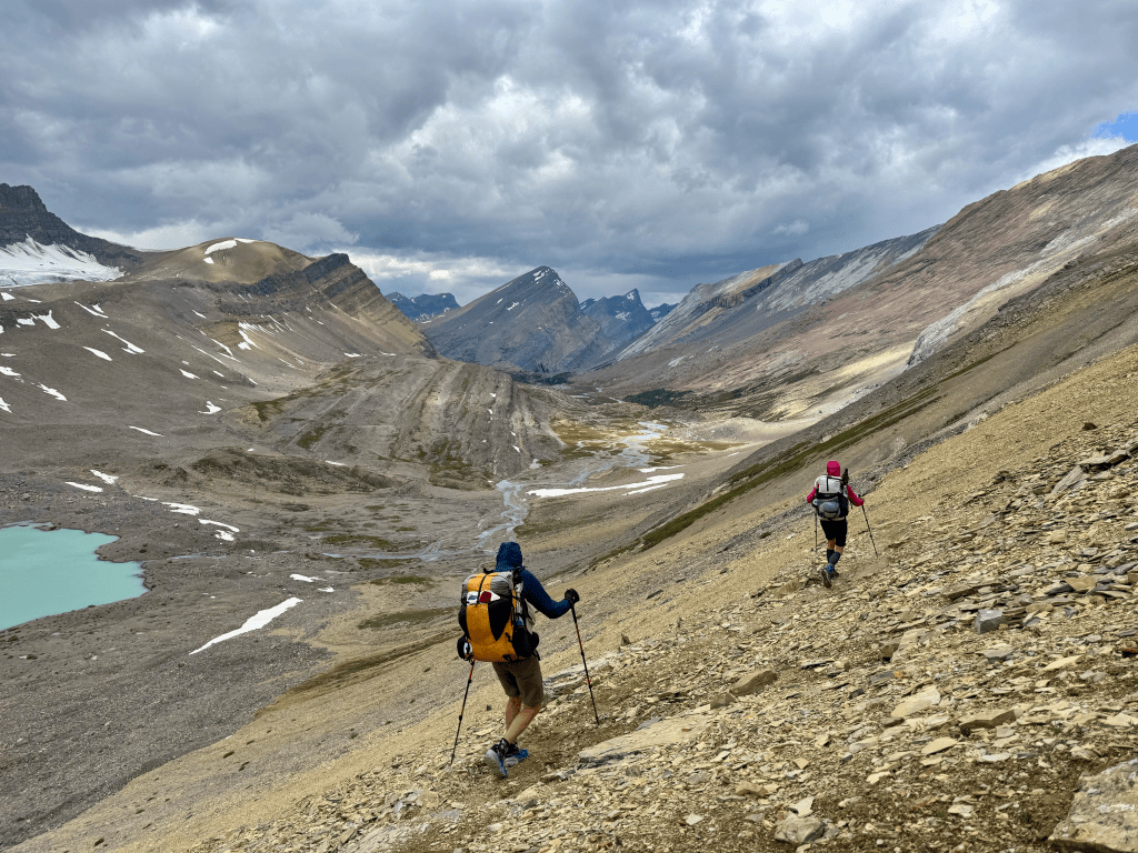
Rained good last night and it was still raining by the time I usually get up. Since I got ahead of schedule yesterday I made the obvious choice to sleep in. Not to mention I can’t really go much further than twenty or so miles today. I checked the weather on my inReach and it said 90% rain at 8AM with it decreasing 10% every hour afterwards. The biggest issue was the temperature was in the forties, that combined with rain is bad. I waited until ten to start hiking, it was still raining but I didn’t want to wait any longer. The forecast said it wouldn’t be completely clear until late noon and there was no way I was gonna wait that long. While packing up one of the other campers came up and told me a black bear tried getting into some food bags. When I checked mine sure enough a bear had attempted to ransack it. My bag was the new Adotec bear bag and it did its job. There were claw marks all over and small punctures but it kept the food away from the bear. However, when I looked inside I noticed much of my food was torn open. The bear must’ve stomped and clawed at it for so long that it still damaged what was inside. I lost about a days worth of food, I was pissed. Back on the trail I ran into the other hikers again and one of them had the same problem, all her food inside got smashed up. She said the bear came by around 7am. At noon it stopped raining so I took a break at Lambe Creek CG to further access the damage. A few ziplocks were punctured along with my opsak, a bunch of bars, and my Peak Refuels. I was able to duct tape the holes on the Peak Fuels so I hope that works. Looks like I’ll have to buy more food than expected at the Crossing Resort.
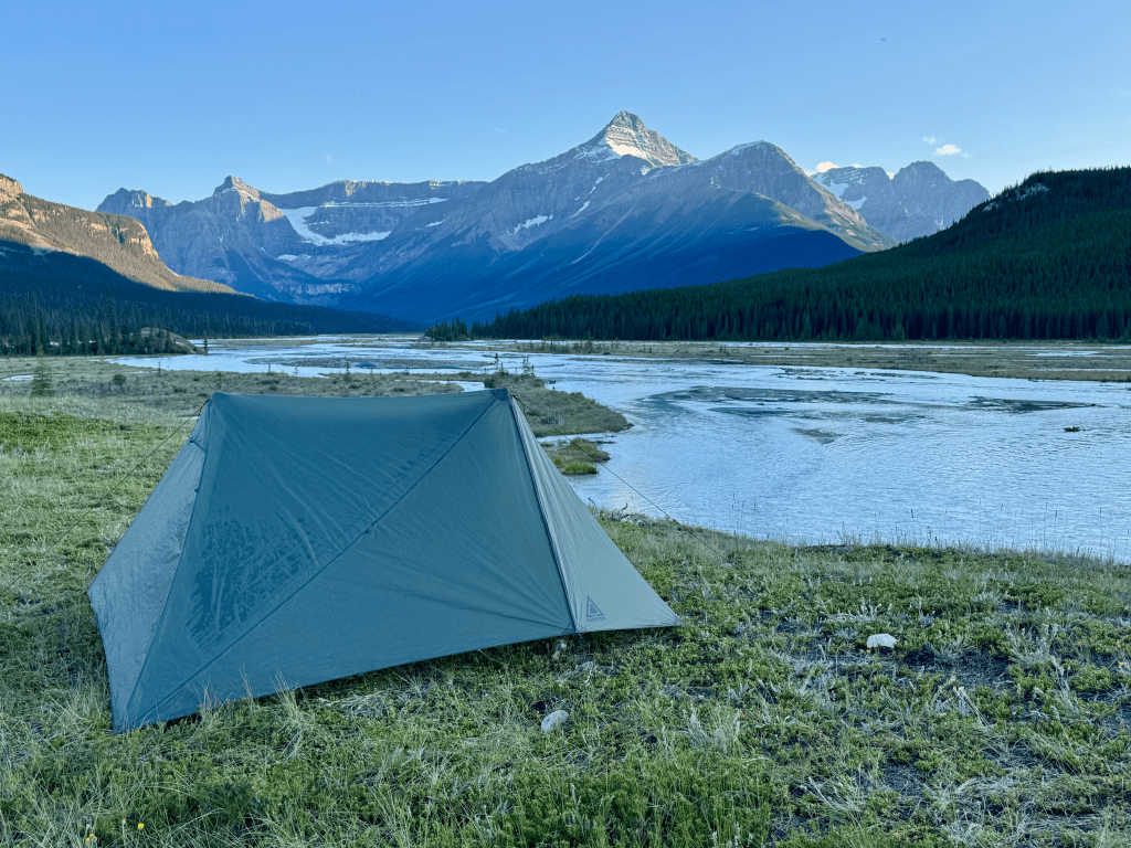
At late afternoon I reached the Howse River Floodplains and for the rest of the day I was walking through a wide open range with the Rockies on either side of me. It was one of the most scenic places I had ever been. The floodplain was easy walking even though there was no trail. Every now and then I had to go into the bush which sucked but it would eventually lead me back into the open. There were so many good camping options that I might have to come back just for this section. At 8PM I reached my campsite at Howse River CG. It’s one of the most picturesque spots I’ve ever camped at. There’s a peninsula that overlooks the floodplains and I was the only person there. Lucky me. Pitched my tent and took a bunch of pictures. Even though I only hiked ten hours it was a long day for many reasons.

Day 4: 22 miles
Woke up at six with the plan to sip coffee in front of the great view but when I unzipped my tent all the mountains were buried under fog. Bummer. Started hiking at 6:35 and it was easy wet trail until I made it to the road. From there it was only a few miles to the Crossing Resort. The flat pavement felt incredible after yesterday, I was cruising. Made it by nine and went straight to the breakfast buffet which was open until ten. I needed the calories because I ate less yesterday because of that bear. After breakfast I went to their small store and bought 5,500 calories. They had a very limited selection so I’ll be eating almost the same thing every day until Jasper. I hate that bear. Between breakfast and the resupply I spent around 85usd which I guess isn’t bad.
I left at eleven which was earlier than expected. It was a one hour road walk until I reached Owen Creek TH and from there it was a 3,500ft climb in 6 miles. The first three miles had been recently maintained by GDTA crews which was awesome. The last three miles is where it got really steep, that’s where the real climbing started. Much slower travel and had to get my feet wet a lot. A common practice on the GDT. Eventually I made it out of the tree-line and into the open and was blessed with great views all around. I made it to Owen Pass at 4PM and it was windy but had exceptional 360° views. I cruised downhill and once at the bottom you go right back up to the highest point on the GDT. It’s only 8,500ft but feels much higher. Took the time for more pictures since it was less windy. From there it was fun cross country travel down into the tree-line before once again going back up to Pinto Pass. This section was a roller coaster. Slow moving but fun so I can’t call it a PUD. On the way up it rained for about ten minutes. It’s rained on me everyday of this trip so far. Thankfully it cleared up when I reached Pinto Pass. That was the final climb of the day. After a steep descent I reached Pinto Creek CG at 7:45. It’s an old horse camp so there was lots of horse poop around. There was also a lot of stools and benches to sit. I got a great pitch of my tent before making dinner on a table that was built into a tree. I don’t like eating this close to where I sleep but there’s no doubt this whole place reeks of food already. I hung my bag within eyesight so if a bear tries something again I can at least holler at it. Today was a big day doing those three climbs back to back


Day 5: 22 miles
I haven’t fallen asleep before midnight on any day so far. Only got a few hours last night. Didn’t help that it rained off and on which kept me up. At six it was still raining so that gave me the excuse to sleep in until 7:10. Really didn’t want to get up but had to. Did things a little differently and just packed up my sleeping bag and kept the tent up in case it rained again. In the meantime I made breakfast on the provided table again which was just a ProBar and hot coffee. It’s pretty chilly out this morning, fifties and breezy. Started hiking at 8:15 and the trail was wet but decent. I was able to keep a solid pace down to Pinto Lake which had two good campsites, one was very popular with loads of people. From there I paralleled Cline River which then became Cataract Creek for a few miles. That led me towards Cataract Pass through a wide canyon that was pretty boring. Eventually I broke through treeline and finally saw the good stuff. The final climb up Cataract wasn’t bad, it was windy though. The view decending Cataract was one of the best I’ve ever seen. It actually made me say “holy shit”. Even though it was windy I had to sit down and take it all in. Heading down the pass it started raining again, I am now 5/5 for rain on this trip. Once I got to lower elevation the trail finally became what you would expect from a popular national park. It felt so good be on a nice graded well maintained footpath after the last few days. I was cruising and before I knew it I reached Four Point CG at 6:30. I did not have a permit so my original plan was to eat dinner and then do another mile to Cline CG which is decommissioned. However as I was eating a man approached and asked if I was a GDT hiker. Turns out he’s a guide and runs his own company, he was there with five clients. He told me I can just stay at the campground because there’s many flat spaces that aren’t even designated sites so nobody will care if I pitched a tent. Don’t mind if I do, this actually saves me a couple miles because Cline is off trail. He also gave me his contact info because he lives in Jasper and occasionally hosts hikers. That would be dope because Jasper is very expensive. His name is Christian Roy and his company is Canadian Skyline Adventures. I was gonna stay up and shoot the shit with them but it started raining again so I jumped in the tent instead. It was nice to have an early day due to all the lack of sleep. It’s now thundering pretty good as I type this
Day 6: 28 miles
Again I didn’t fall asleep until after midnight. There was a huge lightning storm that probably kept the whole campground up. Got up at six even though it was still raining, I had a big day planned. The toilets at Four Point are all open air and offer no cover so I had to shit in the rain. Might be a first for me. Started hiking at 7:20 and for about eight miles it was all exposed with sideways rain and temperatures in the 50s maybe. Really miserable. I just put my head down and grinded it out. That only lasted the first few hours, after that the rain cleared which was amazing, still cloudy though. Perfect timing as I made the climb up Jonas Shoulder which had amazing 360° views. I took a small break up there to take it all in while the weather was good. On the way down I finally saw a grizzly bear. It was far away on my right grazing for food. I made my presence known and kept moving. From there the trail went back into the treeline and got muddy and boring. It rained off and on and the sun even came out for 15-minutes and then left. I made it to Avalanche CG at 5PM and took my dinner break there. Kinda perfect with Maligne Pass 2.5-miles away. It was completely empty even though I guarantee it was fully booked online. Heading up the pass and it started raining again but cleared when I broke treeline. Great views at the top right in between Cotter and Replica Peak. Got to Mary Vaux CG at 7:20 which was exactly twelve hours of hiking. I have a permit here so I can’t go further. Sure enough I am the only person here. This “campground” did not have any tent-sites like the other ones did. Seems like it’s not too popular. The only two flat spots are right across from the bear lockers which doesn’t seem ideal. Looking out my vestibule I’m probably only 30ft from them, hope I don’t get a visitor tonight. I don’t recommend this campground. Today was a long and wet day. I had my rain gear on the entire time which I’m not sure I’ve ever done. I’m in my tent and everything is wet and nasty. Funny that the worst weather day so far was also my longest planned day of the trip. Go figure.
Day 7: 24 miles
First night on trail I slept decent, really needed it. Got up at 6:15 and of course it’s sprinkling already. I hate the sound of rain hitting a tent. Did my morning duties and hiked out at 7:20. The entire first 2/3 of the day was wet and muddy. Not to mention a lot of huge willows to walk through. I got to Maligne River which is usually a tough ford but it was pretty easy even after all the rain. I made it to the Maligne Lake Chatlet at 1:50 and holy shit they had one of the most epic buffets I’ve ever had. Made by legit chefs it had it all. Orzo pasta, potato salad, brisket, roast veggies, chicken, salads, pasta marinara, cheesecakes, cookies, chocolate cream puffs etc. They normally only serve the tour groups but the man working the front named Travis let me in. He’s fully aware of the GDT and how much we eat. It cost $50cad but totally worth it. Completely made my day after all this rain. After I gorged myself I started hiking at 3PM and was blessed with great trail heading up Little Shovel Pass, at times it was a five foot wide path. On top of that the weather cleared up. With a stomach full of good fuel I cruised all the way to the pass and made it to Snowbowl CG at 6PM, my final permit. As I approached it started raining yet again, I just can’t catch a break with this weather man. I found a flat spot and pitched there. Noticed a surface shit about 10’ from my tent, gross. Today was like two different days. The first part was miserable with nasty muddy trail and on/off rain. The last part was great with the buffet and great trail.

Day 8: 27.5 miles
Started hiking at seven and it was all great trail. I walked through a wide open alpine area with mountains on either side towards Big Shovel Pass. After the pass I looped around a bowl towards Curator Lake which then led up a steep climb towards The Notch. At the top I had good cell signal so I quickly got caught up on pointless things after the last eight days. Unfortunately this is when the clouds started rolling in. I had heard that the section north of the Notch is incredible but unfortunately for me I couldn’t see any of it during the ridge walk. Huge bummer. It could’ve been worse though, it would’ve been miserable to be caught up there with terrible weather. As I descended the ridge the clouds moved out a little but then it began raining. I am now 8/8 with rain. It didn’t last too long and when it stopped I looked back at the ridge and it was clearing up, so unlucky. The rest of the way was all downhill, I reached Signal Mtn Road at 1PM and started descending down to Jasper. Almost immediately I was walking through the huge burn scar from last year’s fire that almost burned Jasper over. I made it to downtown by 4:30 which was earlier than expected. Crazy how fast you can go on an actual trail. First thing I did was hop in the pizza shop and devoured a 12” pizza. It was chorizo, pineapple, cilantro, onions, cheese, and jalapeños. It didn’t stand a chance. After that I headed over to Chris’s house (the guide I met the other day) and crashed on the floor of one of his rooms. He was there with another guide prepping for a trip in a couple days. They made dinner and offered me some so why not, I need the calories.
Day 9: 0 miles
Slept well last night at Chris’s place. I stayed in his room where he organizes food for his guided trips. I threw my NeoAir Xtherm on the ground and called it good. Saved me a ton of money because every place in Jasper is at least $300 on a weekday. I went to the Wafflato for breakfast and it was great. Three eggs, bacon, sausage, hashbrowns, toast, watermelon and of course coffee. From there I went to the hostel which is conveniently located in the middle of town. I booked one of their private rooms which even with my 10% GDTA membership discount it was still $320. It was around 8AM and I couldnt check in until 4PM so I had lots of time to kill. I chilled in their lobby while drying out my tent, charging electronics, and laundry. This isn’t a normal hostel you’d see on a long trail, it’s very large and caters more towards regular tourists than hikers. I also took the time and scheduled a taxi ride tomorrow to skip the 14-mile road walk and also managed to schedule a shuttle out of Bastille Creek TH after I finish, that saves me two extra days of road walking after I finish. Expensive but worth it. I went to the Totem Ski Shop to buy a new fuel canister, I got water inside the other one so it was acting funky. I checked into my room afterwards and also collected the box I had sent there. I had to pay an additional $25 because apparently that’s what it cost them to pick it up. Once in my room I let my gear explode all over the place and did some more town chores like cleaning my Jet Boil. The room had a TV, private bathroom, and heat/AC. Not bad for a hostel, but that’s why it cost three bills. Spent the rest of the day eating more food, relaxing, and walked around Main Street a little to act like a real tourist

Day 10: 25 miles
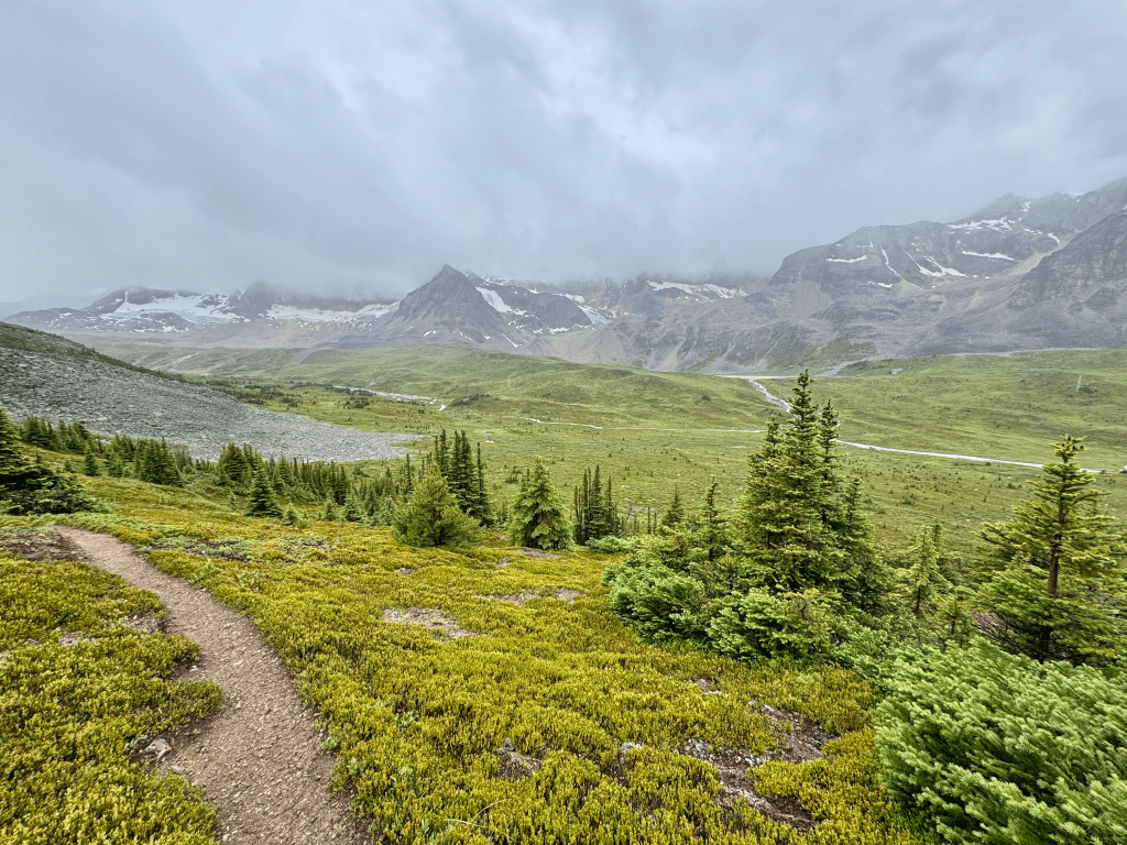
Slept great, nice to actually get some recovery. Went back to the Wafflato for breakfast and then back to the room to shower and pack up my gear. I’m carrying over 20,000 calories which might be my biggest carry. I was gonna pack out a cinnamon bun from the bakery but it was packed so I just bought a banana instead. Keep it a little healthier. My taxi arrived on time and I was back on trail at 11:30. Felt good to skip a 14-mile roadwalk on a highway of all places, screw that. I had an easy three miles on a dirt road before I turned into the woods. This is where it got shitty. The trail was there but it was very overgrown and had lots of blowdowns. Extremely slow going and miserable. That section could use a chainsaw or two. After about six miles it started to clear out thank God. Not long after that I tore a massive hole in the side of my right shoe, maybe four inches. Great timing on the day I leave Jasper which has unlimited shoe options. Now I have to make these last another week in rough terrain. I heard so many good things about Topos one of which that they are “bomb proof.” This is now my second pair that have torn in under 500 miles. Going back to Altra after this. Anyways, around 7PM I walked through Miette Pass which was a wide open boggy area with 360° views. No trail but is was surprisingly easy to walk, lots of mosquitoes though. I decided I was gonna push a late day to Colonel Pass CG. I like to push late days leaving towns since I get a late start and I’m well rested. Not to mention the insane amount of daylight, it’s 10:17 as I type this but still not dark. I made it over Grant Pass around 9PM which had good views. The trail kept on disappearing on me which was annoying. One minute it’s great and the next it’s gone. I made it to the campsite at 9:45 and there’s another tent there, wasn’t expecting that. I walked a bit further and found a decent spot off trail. Latest day of the trail by far. I’ll probably hike until at least 8PM from here on out since there are no more permits to worry about


Day 11: 24.7 miles
Started hiking at 7:45, a bit later than normal because I decided to sleep in after the late day yesterday. The section from Colonel Pass to the Colonel Creek Trail Junction was littered with blowdowns, slow going. The trail got better after the junction though. Around late morning I did my first of many fords of the Moose River. The trail parallels it for many miles and every now and then you must ford it. They were all easy but navigating was a pain because the trail would come and go. The midday heat started to pick up. Yesterday was the first day on trail it didn’t rain and today is looking great too. This weather is the opposite of what I had from Field to Jasper. Eventually the fords ended and I started making my way to Moose Pass which just like the other passes had incredible views. From there the trail was all downhill which felt great. Made a pit stop at Calumet Creek CG for dinner and then began pushing another 8.5 miles. At 7PM I reached Smokey River and quickly realized the river at this point in the day was too much. I spent twenty minutes trying to cross in different locations but it was either too fast or too deep. I made the wise decision to end the day early and cross in the morning. I was pretty upset because today was gonna be a thirty mile day to Wolverine. Sucks to end the day with so much light remaining but it was the smart thing to do

Day 12: 29 miles
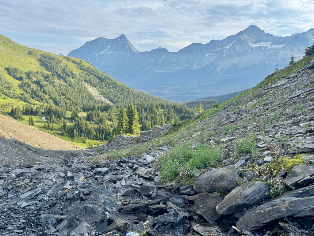
Got moving at 6:45 and it only took a few minutes to cross Smokey River, however it was still a bit more difficult than I thought it would be that early. It was a sign of things to come. A few hours in I had to ford Carcajou Creek. I bushwhacked a hundred feet downstream and did it there. Pretty fast current that got mid-thigh on me. From there it was five miles to Chown Creek which is another notorious ford. However I did it a little differently. There are two routes and I kinda just did both. I started going in between them and zigzagged my way through the open field. I forded Chown maybe eight times, deepest it got was mid thigh. It was a very engaging section just walking freely with Mount Bess in the background. After that I made my way up Bess Pass and towards the top it turned into Willow Hell. Willows taller than me on both sides grabbing you as you go, didn’t help that part of the section was muddy. Yuck. Bess Pass is a covered pass, no views. You immediately start the steep climb to Bess Shoulder after the pass and it begins with more willows. The climb is over over 1,000ft in under a mile, pretty steep and slow going. At the top I had to make a LMNT drink to replenish a bit. Also great views in all directions. From there it was a PUD. I went two miles down to Jackpine Pass CG only to go up to Jackpine Pass. Once at the pass it’s a sharp turn onto a wide open cross country section. On the way up I found a nice water source so I took my dinner break right in front of Mount Chown and Mount Bess, not a bad spot. From there I entered the Jackpine Alpine Route which turned out to be one of the highlights of the entire trail. It’s hard to even describe, words wouldn’t do it justice. For about seven miles you are well above treeline with grand views in every direction. Surrounded by mountains, some close, some far, rolling green hills and an occasional pond of water from snow melt. It was easy to get misdirected so I had to check my phone frequently. Towards the end I started rock hopping which was shredding my shoes. They’re already blown open on the side and I’m worried about them making it to the end. The day started to wear on me the last couple hours. The off trail travel was slow and I kept getting off the track. I felt like the topographical map didn’t line up with what I was seeing at times. Eventually I made it back to trail and it was a quick one mile down to Blueberry Lake CG. The sky decided to rain while pitching my tent and then immediately stopped when I finished, weird. This is one of the most scenic tent-sites I’ve had on this trail. A nice lake in front of me and mountains behind it. Today was my toughest day so far, almost thirty miles. Had to make up for the premature end yesterday. Started with the tough fords, then the cross country travel through Chown River, the muddy willow mess up Bess Pass, then the steep climb up Bess Shoulder, followed by another climb up Jackpine Pass, and then finally the seven mile off trail alpine route. Long day.


Day 13: 27 miles
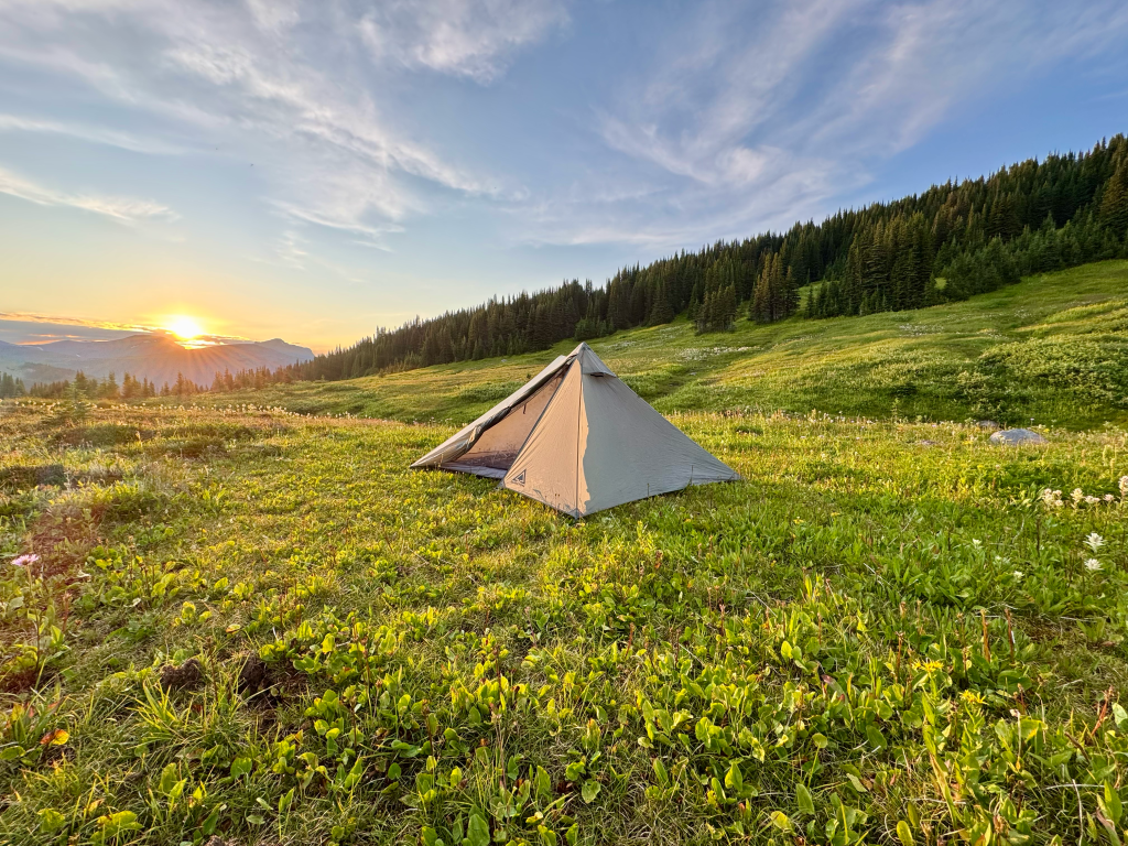
Got up at six and decided to take advantage of the nice camp. I doubled up on coffee and made some oatmeal. I only packed two bags of oatmeal for this section so I wanted to save it. Did all my chores and started hiking at 7:15. Had great views Jackpine Mountain and Mount Holmes for the first two miles before descending down to Jackpine River. From that point on I weaved my way through the river countless times, one ford after another. Lucky for me they were all easy. I read comments on FarOut and apparently some people weeks ago couldn’t ford it so they bushwhacked their way through. That sounds absolutely horrible. This section also happens to be flat as a board and was cleared out by trail crews in 2021/2022 so I was putting down a good pace. I had 9.5-miles done in four hours, rare for this trail. The mosquitos were bad in this section so it forced me to keep going. Around 1:30 I got an afternoon storm and some rain rolled in. I found a nice dry spot under a tree to finally get a break. It was only a few more miles until I was finally free of Jackpine River, felt so much better going into the high ground. Night and day difference. I started the climb up Little Shale Hill which was wet, boggy, and muddy most of the way up. Not fun. It also rained off and on. At the summit it was nice and breezy which kept the mosquitoes away. Took a ten minute break before going back down. At the bottom I took my dinner break and ate my last Peak Refuel, the best freeze dried meals in my opinion. Then it was up a huge climb to Big Shale Hill. It was about 2,500ft gain in 2.5-miles. The last 1,000ft is when you break tree-line and that’s where it got steep. I lucked out with the weather again and thank God because when I reached the summit it was the best view I’ve ever had on trail, no joke. Definitely the best on the GDT. Not only insane 360° views but it was near sunset and it was dead silent. If I closed my eyes it would’ve sounded like I was sitting in a room by myself. Crazy to be that high up, wide open and that silent. I stayed for a bit to take many pictures before departing. Made my way down to Shale Pass CG by 9PM and called it a day. Great wide open camping with minimal tree cover. Got to watch the sunset while pitching my tent. I have a feeling it’s gonna be cold so I threw on my long-johns finally.


Day 14: 26 miles
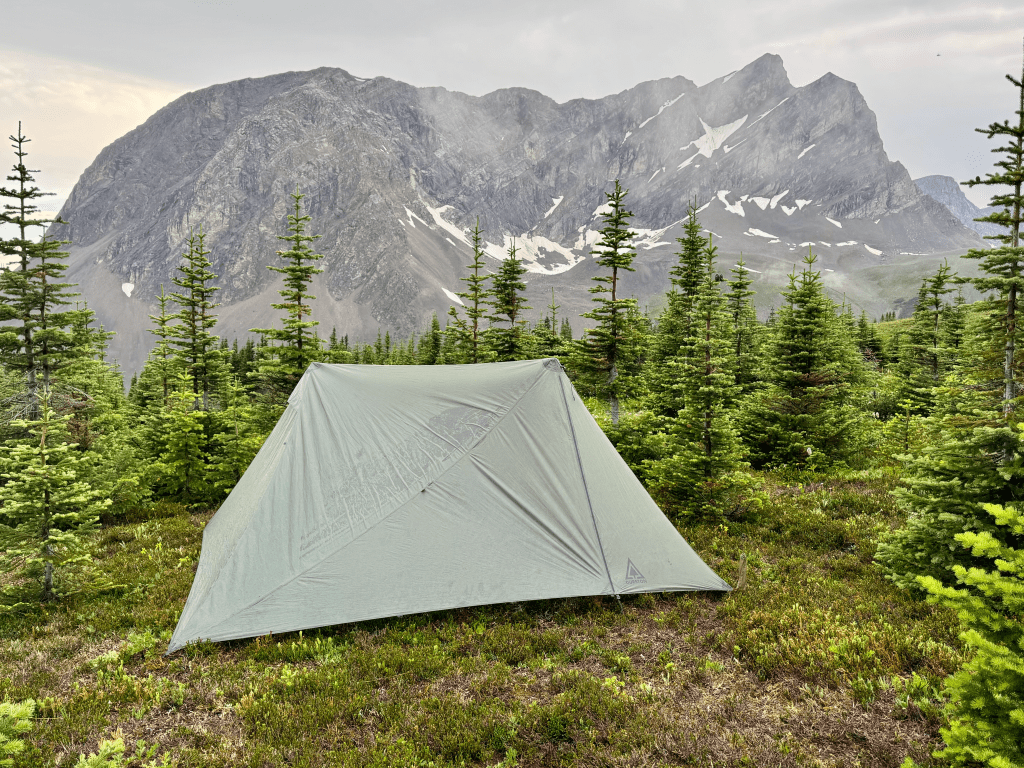
Best night of sleep on the trail so far. I was out like a corpse and actually had dreams which meant REM sleep. It was also surprisingly warm. I didn’t dread getting out of my bag at 6AM like I usually do. While packing up it started drizzling on me so I decided to not eat breakfast there since it was wide open with no cover. Last thing I want is to get rained on with all my gear out. Hiked out at 6:30 and found a nice spot 15-minutes uphill with a nice view of Big Shale Hill. Ate my last oatmeal and doubled up on coffee again. The day started off pretty boring until I started making my way up Mount Morkill Col, the approach is through a meadow and it started drizzling again pretty so I threw on my rain coat but not rain pants. The trail this morning was good aside from the occasional bog here and there. Made it to Morkill at 11:30 and took a nice break there. It was a bit chilly with cloudy skies and a north wind but it kept the bugs away which was nice. Had a great view of Mount Verdi and the surrounding mountains. I’m not in a big hurry today because either way I finish tomorrow. At around 2PM is when the day started to suck. I was descending Fetherstonhaugh ridgecrest (which was beautiful) and many FarOut comments said the trail north was very bushy. As I hiked the trail was actually great and was clearly constructed in recent years. I thought I was in the clear but it turns out that only lasted three miles. After that is when the thick willows came back. Not as bad as Bess Pass but what made it miserable was the rain that came with it. I made the mistake of going through one patch with my base layers and was instantly soaked. I immediately put on my full rain suit and the remainder of the day was wet brushy trail with temperatures maybe around 60°. Not the best time. I hauled ass and made it to Copper Kettle CG at 5PM and took my dinner break, that hot food really hit the spot. It was too early to stop so I pushed on in the rain. I started walking through a huge meadow when I saw a grizzly on trail. I hollered at it and it stood on its hind legs to look at me. Then it started running parallel to me so I took out my bear spray and flipped the safety off. I continued to yell at it and raise my arms and luckily for me it just ran into the woods. My heart was pounding after that. Not even ten minutes later I saw another grizzly also right on trail. I did the same thing and just made noise. The bear looked at me for a solid ten seconds before taking off. The rest of the way from there I was on edge with frequent bear calls. Took no chances. At 7:15 I decided to camp right below Surprise Pass for a more scenic final campsite. The bugs were bad but I had great views of Bastille Mountain on one side and Mount Cote on the other. Everything is wet and nasty inside the tent, I guess it’s only fitting it ends this way as it has rained 10/14 days. I spent my final night watching the sunset over Bastille Mountain and Surprise Pass from within my tent


Day 15: 14.5 miles
I thought I was gonna sleep in but I started packing up at 6:30, it’s hard for me to sleep in when it’s light out. I enjoyed my last cup of trail coffee from within my tent while looking at the morning light cast on Bastille Mountain, not a bad final breakfast spot. It was only 1.5-miles up to Surprise Pass and I made it pretty quickly. I decided to take the Surprise Pass High Route since I had a good weather window. The route was entirely off trail and well worth it. Great views as you would expect from any high route. It’s only six miles and by that point I had done harder routes on the official GDT. It started with light bushwhacking up a hill which soon turned into a long rock field. As soon as the rock hopping got annoying it ended and I started making my way up Wapiti Mountain. It was about a 650ft climb in 0.6-miles. At the summit I noticed there was no carin so I made a small one. On the way down I had a great view of Kakwa Lake in the distance, I could see the finish line! However, when I reconnected to the main route it turns out the trail was very overgrown, bushy, or simply not there at times. I was not expecting this so close to the end. I took a break at Broadview Lake CG and met another GDT hiker. He was taking a zero day at the campsite which I think is crazy any thru-hiker would want to do that. From there I had 5.7 to the finish and of course the trail was a mess. Very faint trail if at all. Lots of mud, some more willows, and constant route finding. This section could really use a trail crew but I guess it makes sense it ends this way. It only took me two hours before I reached Kakwa Lake 3PM. The terminus sign is a bit further down the shore line so I immediately went there and just like that it was over.
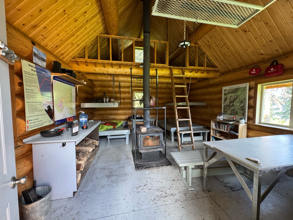
I was not expecting what came next. I walked into the free cabin and there were two other hikers there on a weekend trip. Turns out they overpacked food and were willing to part ways with it to lighten their packs. This was music to my ears because I was running low. They immediately shoved bread, cheese, deli meat, hummus, and butter in my face. I wolfed it all down while chatting with them. I went over to the other cabin which two parks employees live in one month at a time. They invited me in and gave me their WiFi password, apparently they have Starlink out here, what a pleasant surprise. They also offered me food so I sat down with them and ate a salad and more cheese and bread. Chatted with them for a while and they gave me a free neck gaiter for completing the GDT. They also let me shower in their back shed. They had to boil water and then I mixed it with cold water and turned on a pump which spit out the water. It felt amazing, never showered like that before. There was a second couple there who flew in on a float plane and was also staying the night. They were able to catch a rainbow trout and cooked it up for all of us. Never had fish that fresh before. The other couple also made me some Knorrs pasta sides with cheese and eggs mixed in. This all tasted so good. I was worried about having to stretch my trail mix for two days. In the evening all seven of us sat by the campfire and chatted. This is what it’s all about out. Seven strangers who just met talking to each other with no distractions

Post Hike
The GDT is unique that it ends in the middle of nowhere. What most hikers are forced to do is an additional 65-miles on trail/road to reach Highway 16. That makes it a 225-mile stretch from Jasper. The only realistic way to shorten it is to pay for a ride and right now only one company offers it, Robson Adventures aka Jasper Hikes and Tours. I contacted him (Sean) in Jasper and scheduled a pick up. It costs $627cad for a one person private shuttle because it takes him 8+ hours round trip. This ride was scheduled for 2PM on August 5th which meant I had to take a zero at Kakwa Lake since I finished on the third. I really enjoyed the zero because Kakwa Lake has so many amenities. There were four other people with me in the cabin and of course the two hosts in their own. The four others both left on my zero which meant they cooked me up some bacon and eggs twice to lighten their load, yes please. Turns out the hosts are also leaving the fifth and they are parting ways with any food. Incredible. I spent the day just chilling by the fire pit looking at the beautiful lake on a gorgeous day while listening to music. Not a bad way to end a hike. The hosts (Steve and Diana) had me over for dinner and made a feast of Indian food. My mouth was watering. The three of us devoured it and afterwards we split some chocolate and had tea. Before I left they gave me more food for tomorrow. Great people. I went back to my cabin, threw wood in the fire and listened to some podcasts in my bag
The next day I started hiking at 6:20. It’s 18-miles to Bastille Creek TH and it was easy walking compared to the GDT. I was easily going 3+MPH which felt amazing. I was way ahead of schedule so I took a nice long break at a snowmobile cabin 11-miles in. The sign says it’s open for anyone in need so I went in and made myself another coffee. Spent a good 90-min there before heading out and two hours later I made it to the trailhead and I’m officially done hiking in Canada. Sean arrived on time and picked me up and it was a long drive out to McBride. Very worth it to skip that road-walk, no regrets. I stayed at the Ravens Nest Hotel in town and booked my train and plane tickets out of Prince George the following day.


TRIP REPORT & GUIDE
ABOUT THE GDT: It’s 680 miles from the border of USA/CAN at Waterton to Kakwa Lake through the Canadian Rockies. There are seven sections of this trail, A through G.
RESOURCES: Plenty of resources online for free. I bought the book but if I could go back I would save the money, I only flipped through it a few times. The GDT Facebook group was probably the best. Lots of good advice and up to date information there. The GDTA website also has a wealth of information
TEMPS/WEATHER: I experienced everything from 45 to 90 degree temperatures. Very volatile weather on the GDT, you must prepare for it all. When I started it was at the tail end of a heat wave and in Banff I had temps in the mid 40s. I also had crazy rain and hail storms. The rain can be rough. Most people recommend legit rain gear and I would agree, it can get pretty cold and wet. For me it rained 16/28 days of hiking
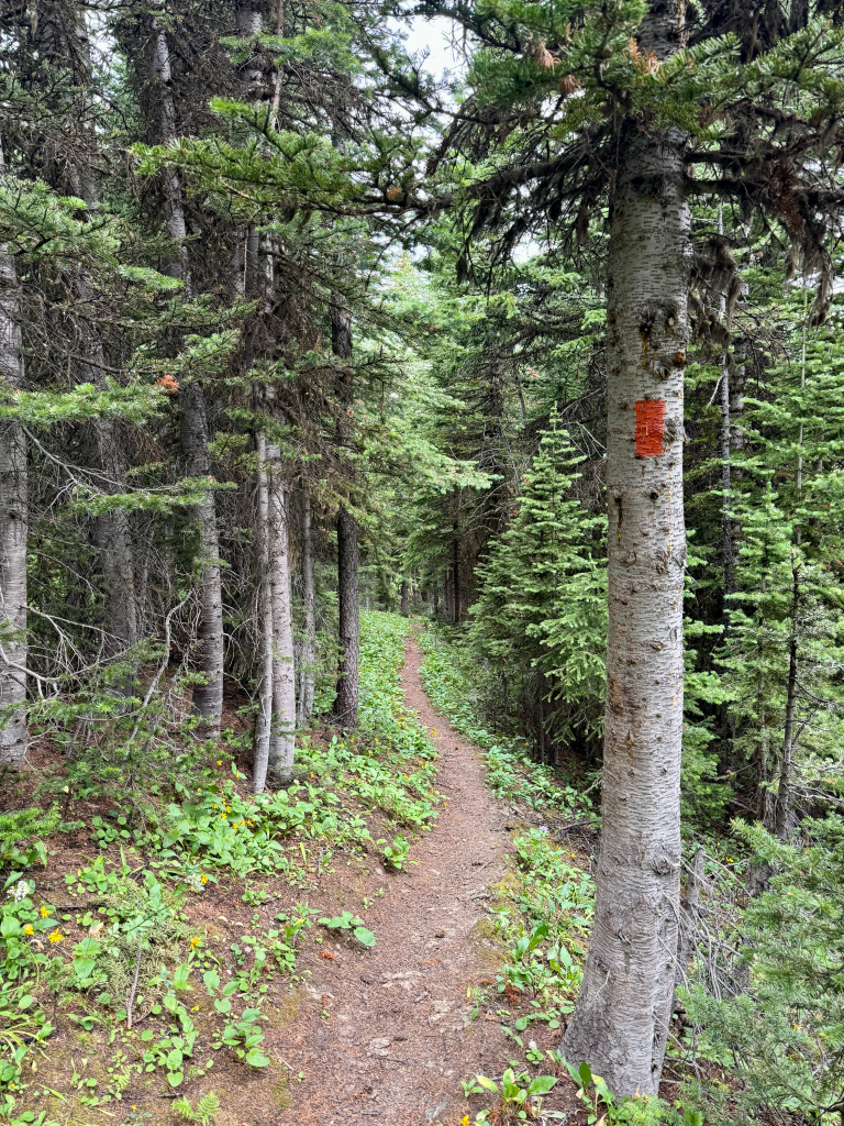
NAVIGATION: I used FarOut 90% of the time and occasionally I looked at Gaia and All Trails. I had paper maps for emergency. The biggest benefit to FarOut are the comments, you can get up to date information on everything by looking at them. I also used the Thunderforest background map on FarOut, I found it to be the best option out of the bunch, good topography with marked trails and named peaks. There are sections where you will find yourself constantly looking at your GPS because there simply is no trail. You could be walking on a nice 18″ dug out footpath and all of a sudden it ends. Much of the trail is also marked with orange flagging, so it’s kinda like connecting the dots.
WATER: As you can imagine water is not a big issue on the GDT. I think the biggest dry stretch was 10-12 miles. Most I carried was 2.5L and never came close to using it all. Many times I only carried 1L and was fine
WATER CROSSINGS: This can be rough depending on the rainfall and when you get there. I noticed there were comments on streams and rivers being “easy” a week prior but when I got there it was deep and fast moving. Smokey River was the worst for me, it’s the only water crossing in 12,000-miles of hiking that forced me to stop and cross it in the morning. There are also a few sections like the Moose River and Jackpine River where you will be forced to ford it a dozen plus times which can be tedious
GRIZZLY BEARS: The Canadian Rockies is home to a healthy population of grizzly bears so this is obviously a big concern for a lot of hikers. You must protect your food and follow the guidelines to prevent bad encounters. Make noise in thick brush and around blind corners, don’t eat where you sleep, try to hike with others, carry bear spray and have it easily accessible, and avoid hiking during dawn and dusk (I always break this rule). If you do encounter a bear make yourself known, do not try to sneak around the bear. Do not approach a bear or any wildlife, give them space. Do not run from a bear, Olympic sprinters can’t outrun any bear. If a bear charges you it’s most likely a bluff charge, stand your ground and make yourself big, be ready to deploy bear spray. If a bear attacks roll onto your stomach and protect your neck, play dead. If the bear starts eating you good luck.
BEST SEASON: I recommend late July to early August. It gives enough time for the snow to melt but the downside is more chance for wildfires which is what happened to me in 2024. The trail isn’t long so you have a big window to hike it which is June through September
WHICH DIRECTION: I went NOBO as most do. It’s an easier start with less food and more options to bail out if something happens. Going SOBO you start with the biggest carry and arguably the toughest section with no trail legs. That can be rough. The northern two sections (F/G) are by far the most remote and would make for a difficult way to begin a hike. That being said if I do this trail again I would go SOBO in order to skip the long road-walk on Walker FSR
GETTING TO TRAIL: My original plan was to fly to Spokane and take the train to East Glacier. From there I would hike to the border. I recommend just flying to Calgary and getting a shuttle to Waterton. Saves a lot of time. The following year I also flew to Calgary and took the Rider Express bus to Field. If you want to go SOBO you are very limited on options. There’s one shuttle service (Jasper Hikes & Tours) that can bring you there so you would have to arrange with them. This would require you to get to McBride which is a very small town. You could fly into Prince George and take the train to McBride, or fly to Edmonton and take the bus to Jasper and then take the train to McBride.
https://jasperhikesandtours.ca/gdt-services
GOING HOME: In 2024 my hike ended in Field and there is the Rider Express bus that picks up from the trading post and goes to Calgary, cost $80. The bus arrives at 8:30PM which was perfect since I got there at 6PM. Going home from Kakwa is a bit more challenging. I paid for a shuttle (Jasper Hikes & Tours) to pick me up on Walker FSR, then took the train from McBride to Prince George which is the nearest airport. If you finish at the border then it’s a simple four mile walk back to Waterton where you can arrange a shuttle to Calgary.
ELEVATION: The highest point on the GDT is only 8,500ft and that’s at the beginning of section E going NOBO. Most people will not have to worry about elevation sickness on this trail, but you’ll probably feel the thinner air on the steep climbs. I live in Maine at 40ft and less than five miles as the crow flies to the ocean and had no issues with elevation on the GDT.
PERMITS: Alright, this is the crux of the whole GDT and if you did a search that led you to this I’m willing to bet this is why. The GDTA website has a whole section on permits, they even admit it’s a rough process but we must do it. According to the guidebook they are trying to create a single permit like the PCT but I doubt that will happen anytime soon. Here was my itinerary
2024
July 29: Akamina Creek
July 30: Scarpe Pass
July 31: Lynx Creek
Aug 1: Coleman
Aug 2: (113.3) Random spot
Aug 3: (141.5) Random spot
Aug 4: Cataract Creek Bridge
Aug 5: Tobermory Creek
Aug 6: (Northover Alt) Three Isle Lake
Aug 7: Marvel Lake
Aug 8: Sunshine Village
Aug 9: Banff
Aug 10: Ball Pass
Aug 11: Wolverine Pass
Aug 12: Field
2025
July 20: Twin Falls (5-miles off trail)
July 21: Blaeberry
July 22: Howse River
July 23: Pinto Creek 2
July 24: Four Point
July 25: Mary Vaux
July 26: Snowbowl
July 27: Jasper
July 28: Jasper
July 29: Colonel Pass
July 30: Smokey River
July 31: Blueberry Lake
Aug 1: Shale Pass
Aug 2: South of Surprise Pass
Aug 3: Kakwa Lake
https://greatdividetrail.com/go-hiking/trip-planning-resources/permits/
Make a good effort into getting your permits. Do it early and don’t be too ambitious with your itinerary. Plan for smaller days than you normally hike. On the GDT I did around 75-80% of the daily miles I did on the CDT. There are many permits you need unfortunately, not just campground permits. Just go to the GDTA website and read up on it, no point in me copy and pasting. I highly recommend taking a hard look at the example itineraries and the complete list of campgrounds. I downloaded both of them and had them on the phone. I will post the links below
The list of campgrounds was the most useful to me, I looked at it almost everyday.
My advice is to get a good night of sleep, eat a good breakfast, consume high amounts of caffeine with more on the side, maybe take some adderall, and then sit down for most of the day and plan out your itinerary from Day 1 to the end. You will need those two documents above along with FarOut for reference. The earlier you do this the better chance you have of campsites. That being said, I didn’t start planning my hike until early June and was still able to secure my permits. You legitimately need to be able to tell someone where you plan to be on Day 23 of your hike and exactly how many miles you will do that day along with where you plan to stay that night. It’s a tedious process, I know, I got very frustrated with it at times. The nature of thru-hiking is unpredictable which makes this process challenging. You have no idea what the weather will be like, you have no idea how you’ll feel. You could get sick. You could get injured. You might be forced to take unplanned zeros, etc. So many things can throw you off. This happened to me when both my plane and train were canceled the day I was suppose to leave. I was at the airport when it happened. I rebooked my flight which was easy but all of a sudden my permits were no longer correct and it was too late to get new ones. Obviously, I went anyways. I had already spent so much money preparing there was no way I was gonna cancel because I couldn’t make my permits. In fact, in 2024 I only had one night where I had the correct permit for my trip which was Ball Pass. I never had permits checked because I never saw a single ranger anywhere. Here’s some tips
- Build in zeros. That way if you fall off track you can make up time in town. Space these zeros out
- Plan for smaller days. The trail is a bit tougher to hike but doing big miles is still possible. You should be able to do 75-80% of what you did on the CDT if you hiked that trail. I don’t recommend planning any 30 mile days on your itinerary
- Look at the documents I linked and take note of the popular campgrounds. Obviously, you will need to book those as early as you can. These campgrounds will generally be around Banff and Jasper
- If you find yourself at a campground without a permit (like I did), wait until at least 7PM before taking a campsite. You don’t want to take a site from someone who had a permit for it. I never saw a single fully booked campground on my trip
- You’ll do yourself a big favor if you can hike bigger miles. I’m not talking 30s, even just doing mid-20s will greatly decrease the amount of permits you need. Just go look at the difference between a relaxed itinerary and a fast itinerary.
- Make sure your permits are on the route you intend to take. The sample itineraries the GDTA provides are on the official GDT route, but there are many better alternates that most hikers will take that require different permits and campsites. That’s why it’s important that you look at FarOut while you plan your days
MY RESUPPLY AND TOWN STOPS
Blairmore/Coleman (91): These two towns are next to each other. There is an alternate that goes into Blairmore which many believe should just be the main route because that’s where all the resupply options are. That’s the route I took and I recommend it. There’s an IGA there but I didn’t think it had a good resupply, I got a better resupply at the Circle K next door.
Elk Pass Trailhead (211): You must send a box to this one. The woman in charge is named Nicole and you can find her info on the GDT website. You ship your box to her and she puts it in bear-proof lockers at the trailhead, you can see this in my Northover Ridge video. There is usually a combo lock on it but apparently there was someone at the trailhead cutting off all the locks so she had to put my box in there with no lock. Luckily nothing was stolen. If I hiked again I’m not sure I would do this because it’s a long stretch from Coleman to Banff, about 180 miles. I personally try to go 4-5 days between towns. With this resupply you’re just picking up your box and leaving. However, there is a campground with a small general store down the road.
Banff via Sunshine Village (272.5): Getting to Banff is easy, pay for the gondola and then take the free bus into town. If you time it right it only takes an hour. Banff is one of the most expensive tourist destinations in all of North America. I arrived on Friday and had to pay $568CAD for a room. You can take a bus to a Canmore but the prices there weren’t much cheaper. Resupply is easy due to the size of town. The bus drops you off in front of the IGA. There’s also several gear stores. If you’re a hungry hiker you’re in luck because there’s anything and everything to eat in Banff and it’s all delicious. I really pigged out when I was there
Sask Crossing aka The Crossing Resort (403): You may notice a large gap in mileage between here and Banff, that’s because this was my first resupply of the following year. In-between here and Banff most people will hitch into Golden when they get to Field. The resupply at Sask is very limited, most people will send a box but in 2025 they charged $80 to hold it. Instead of paying that and the postage I decided to leave Field with a few extra days of food and just buy enough from their store to get me to Jasper. I would not plan on a full resupply here. You can stay here but the prices were 300+ and there’s a good chance they will be fully booked.
Jasper (520): This is a full service town that the trail goes right through. Like Banff it is very touristy which means it’s expensive. I had to pay over $300 for a single room at the hostel and that included a 10% GDTA discount. As far as a resupply goes it has everything. Multiple grocery stores, mini-marts, gas stations, and outfitters. You do not need to send a box here.
RESUPPLY OPTIONS NORTH OF JASPER: This is a big decision for NOBOs because Jasper to Kakwa Lake is 160-miles. You’re probably thinking, “that’s a big carry but not that big.” You are right however, you are not done walking once you reach Kakwa. You must still go an additional 18-miles on trail followed by 47-miles on Walker FSR. That brings the total up to 225-miles from Jasper, now that’s a big carry. You have a few options here…
- Carry the full 225-miles. This is only recommended for fit and strong hikers. This was my original plan. If you do this you need to plan at least eight days, do not plan to hike this section any faster than that. Nine to ten would be more realistic. Once you reach Walker FSR you must pray to the hitch-hiking Gods that someone picks you up. This road is not frequently traveled and many hikers do end up going all the way to the end and thumbing it. Plan to do the full 225.
- Resupply at Blueberry Lake Trailhead. This is around 92-miles north of Jasper. It may sound perfect but there are two things you must know. One, it requires a STEEP descent down a trail that I heard nothing but bad things about. I believe the elevation is around 3,000ft down and back up to Blueberry Lake. Two, you must pay a company (I will post the link at the end) to cache it for you. It costs $129 and they give you a combo lock for a bear locker. There is trash disposal at the trailhead.
- Resupply at Blueberry Lake. This is offered by the same company. Instead of you hiking all the way down and back up they will meet you at Blueberry Lake (on trail) and give you your food there. This requires an InReach and costs $399.
- Schedule a pick up where Walker FSR meets Bastille Creek Trailhead. This is what I did. Once again this option is offered by the same company as the previous two options. This means the hike from Jasper is 178-miles with the final 18 unofficial miles being incredibly easy, it took me 6-hrs to cover that distance. It is mostly downhill and a piece of cake compared to the GDT. So this means you not only skip the 47-miles of road walking but you also get a ride into the town of McBride so you don’t have to worry about a hitch. If you are lucky enough to have two people with you the cost is $209 per person and must be booked ahead of time. They currently only offer this service on Friday’s. However, you can also schedule it as a private shuttle which is what I did because I was hiking solo. This meant I had to pay 209×3 = $627. That is a hefty price but it was worth it. The ride to town takes around 4-hrs one way which means they must spend the entire workday doing this one shuttle, the price reflects that. Much of the road is not easy to drive and is hard on vehicles. Another plus about this option is it allowed me to take a zero day at Kakwa Lake which was an incredible place to relax after finishing the GDT. Most people will leave the following day if they plan to do the additional 65-miles
Note: If you want to make this carry shorter you can skip the 14-mile road-walk out of Jasper. If you are a purist then you’ll probably scoff at that suggestion. Luckily, I am no purist so I paid $40 for a cab ride to skip all the pavement pounding, most of which is on a legit highway with semi-trucks flying by. No thanks, I’ve done enough road-walks. Consider it.
https://jasperhikesandtours.ca/gdt-services
ALTERNATES I TOOK
Mt Rowe/Sage Pass: You have this option less than 20-miles into Section A. The alternate is about 11-miles of all cross country hiking with a big climb to start, much of it is very exposed. Check out the first video for visuals. A lot of hikers skip this alternate because it would be a tough way to start the trail, and the main route is apparently very good. I might be biased but if the weather is good I highly recommend it.
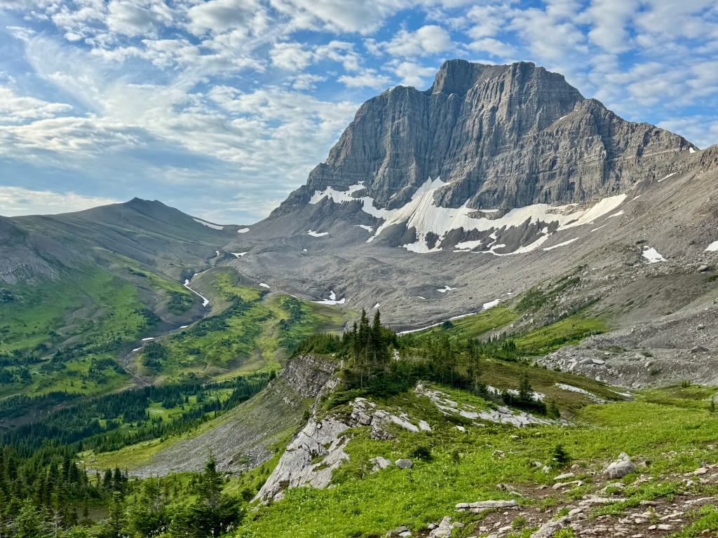
Northover Ridge: Might be the best alternate/section I’ve ever hiked. If the weather is good you have to do it. The views are truly incredible. Physically I found it easier than Mt Rowe/Sage Pass. There were some fear mongering comments in FarOut and I disagreed with most of them. The “knife edge” isn’t much of a knife edge at all. It’s only 0.4-miles long and it’s sloped out very well. By comparison the knife edge after Mount Katahdin on the AT is way tougher and sketchier than this one
South Kananaskis Pass: I only did this because that’s where you connect back to after Northover Ridge
Kiwetinok: This is the alternate the begins section D and is done by almost every GDT hiker. I have not heard very fond things about the main route, apparently it’s not scenic and is a bit overgrown. The alternate however is very beautiful but is not easy. For NOBOs is begins with a massive 3,200ft climb in under 4-miles and ends with some route finding off trail followed by trekking through an overgrown section which connects back to the main route.
Collie Creek: A much shorter alternate than the main route, I believe it saves around 5.5-miles of road-walking. Worth noting that I camped at Blaeberry on this alt and had a black bear try to get into my Adotec bag. You will have to cross a river on a makeshift bridge made out of a few downed trees with a rope overhead. I have a picture of it above for reference, it was very easy.
Surprise Pass High Route: Highly recommend this over the main route. It’s right at the end and will most likely be your last day. It’s only a six mile alternate that’s honestly not that difficult by that point and very scenic. I believe it should be the main route. When I connected it back to the main route the trail was terrible, very overgrown and sometimes not there at all. I spoke with someone who didn’t do the alternate and he said it was like that for most of the section that this alternate avoids.
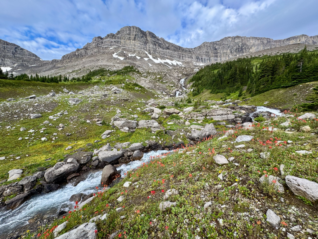
MY GEAR
https://lighterpack.com/r/xwxn02
My full gear list is in the above link. It includes everything I carried on my two sections of the GDT in 2024 and 2025. There are a few pieces of gear worth noting…
Feathered Friends Tanager 20: This is a legit 20 degree bag (not a quilt) that only weighs 19oz. It saves weight because it does not have a zipper, meaning it’s built like a liner. This might be a deal breaker to some people but I like it. I would not use this bag on a warm trail but for the GDT it was perfect. This trail is notoriously cold and I recommend a warmer bag. Feathered Friends is a reputable company and their ratings tend to be accurate
Ursack 15L and Adotec 20L: I used the Ursack from Waterton to Field the the Adotec bag from Field to Kakwa. You are in bear country so you will need to find a way to protect your food. Most people will use these bags but occasionally I saw bear cans which I don’t recommend due to their size and weight. The Ursack I used has been with me since the CDT in 2017, it has never been tested by a bear but they are a very trusted brand. The Adotec bag is new and you’ve probably never heard of it. They are a Canadian company and they offer multiple different bear resistant bags. The main reason I went with the Adotec bag is because they offer a 20L version. My original plan was to carry eight days of food from Jasper to the end of Walker FSR, a 225-mile carry. My 15L Ursack would’ve been too small so I needed something bigger and bear resistant. The Adotec bag not only checked those boxes but the shape is much better than the Ursack which is much more narrow, the Adotec bag fits backpacks better because it’s wider. When I camped at Blaeberry River I had a black bear try to tear into the Adotec bag and it failed. So I can confirm the bag worked against a black bear. The only downside was the bear still managed to crush and destroy about a days worth of food by stomping on it for what was probably a long time.
Arc’teryx Alpha FL & Outdoor Research Helium pants: You want legit rain gear for this trail. Bring a top and bottom that you trust. The Arc’teryx jacket was a late addition because my original plan was to bring my ultralight rain jacket. I had the Arc’teryx jacket for many years but barely used it and I figured this would be the best opportunity. It was one of the best gear choices I made. It’s an all-weather jacket that protected me from all elements, not just rain. The thicker material was awesome for walking through thick wet brush and it kept me warmer than my regular jacket would. The Helium pants surprised me because I always heard mixed reviews about it. However for me they were great, I would’ve been so miserable without rain pants, maybe hypothermic with how wet and cold it got. The pants kept me warm and dry on the worst days. My only complaint is the lack of pockets and zipper. Taking a piss was a bit annoying with them on.
Garmin InReach Mini 2: Might be my new favorite piece of gear. The GDT is very remote and I did it solo. The GDT and the Hayduke are the only two trails I used a InReach for due to it’s remoteness. I can’t compare it to other PLBs because it’s the only one I’ve owned. I used the cheapest plan which was $8/month and paid 10c for tracking (every two hours) and the occasional weather forecast. Speaking of which was very handy on bad weather days which was frequent. It was nice to pull up a spot forecast and know exactly how long the rain was going to be around for. And of course the ability to call for help in an emergency was very mentally reassuring.
Bear Spray: Pro tip, whatever hotel or hostel you stay at before a trip just go to the front desk and ask if they have leftover bear spray from past customers, that’s how I got mine. You are not allowed to fly with bear spray so they are often left behind. A lot of hotels in grizzly country have a decent collection of bear spray. I always keep my bear spray attached to my chest strap, it’s front and center and I can easily access it. I see so many people keep it in the side pocket of their pack and there’s just no way they can deploy it quickly if a bad situation arises. That being said I understand if people refuse to carry bear spray. I have hiked around 2,000 miles through grizzly country (mostly solo) and I’ve never come close to using it or even had a scary encounter. Choice it yours.
Topo Pursuits: Straight garbage. That’s about as blunt as I can put it. I heard so much about Topo’s being the “Altra killer” but it was far from it. I used a new pair for 500-miles on the Appalachian Trail a month before the GDT and they started tearing less than 400-miles in. I decided to use a second brand new pair for the GDT and they ripped wide open 185-miles in. It happened day one out of Jasper which had me worried due to the length of that carry. By the time I reached Kakwa there was a 5″ tear in my right shoe and a 2-3″ tear in the left. Back to Altra’s I go
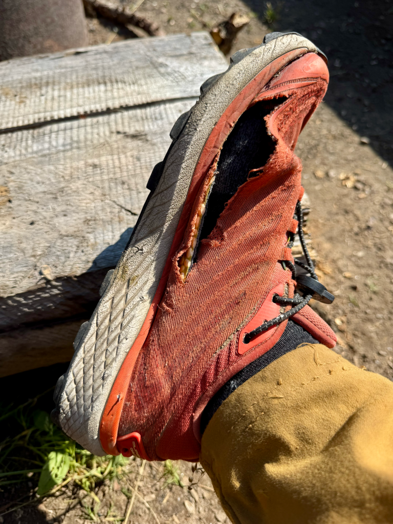
GEAR RECOMMENDATIONS
- Have a warm sleeping set up. The GDT can get very cold at night and the last place you want to be cold is when you’re trying to sleep. Find the right combination of sleeping bag, sleeping pad, sleeping clothes, and tent. I brought a 6.9 R-value sleeping pad because it’s the only inflatable pad I own but it was definitely worth it on this trail. I occasionally wore long-johns at night and they made a big difference. I also enjoyed my 4oz liner, it provided more warmth than expected
- A good mid-layer would be beneficial on cold days. There were times when my base-layer combined with my rain jacket didn’t feel like it was warm enough. I ended up wearing my wind jacket in-between which worked surprisingly well. A synthetic jacket might be much so I would personally recommend a fleece.
- Bring something to cover your eyes. There is a lot of daylight on this trail, it didn’t get dark until 10:30PM and it can be annoying trying to sleep with the sun shining through your tent. I recommend a large beanie that you can pull over your eyes.
- Bring legit rain gear. I already touched on this but when it rains on this trail it can get bad. I had many cold, wet, and windy days and was grateful to have rain gear that I trusted. Not to mention it’s very useful when you’re walking through wet brush that would otherwise leave you soaked to the bone. Also consider rain gloves, there were many times I wish I had a pair.
- Wear pants. A lot of hikers who wore shorts regretted it. The brush gets pretty bad at times and even managed to scrape up my shins through my pants. I can’t imagine how miserable it would’ve been with shorts on.
- Have a tent that can handle high winds in exposed locations. There’s gonna be at least one time you will be above tree-line or camping out in the open. I recommend a tent that can handle such conditions like a mid-tent (X-Mid/Solomid)
SUMMARY
The Great Divide Trail is without a doubt one of my favorite trails and is on a short list of trails I want to hike again. However it is not for the faint of heart and I personally wouldn’t recommend it for beginners. It is a very desolate trail that requires navigation skills and experience in austere conditions like bushwhacking during a cold and wet rainstorm and the threat of grizzly bears and hard river crossings. The permit system is often considered the hardest part of the thru-hike and it’s definitely flawed but it’s a requirement that we must comply with. Get a head start on it and pick your dates as soon as possible. Don’t worry if you are late to the process, both years I hiked the GDT I didn’t obtain permits until June and July. If you are looking for a less crowded trail and a true wilderness experience this would be a great trail to hike, just know what you are getting into and do as much research as possible.
